IMAGES TAKEN NEAR TO
Walmsley Street, STOCKPORT, SK5 7RB
Introduction
This page details the photographs taken nearby to Walmsley Street, SK5 7RB by members of the Geograph project.
The Geograph project started in 2005 with the aim of publishing, organising and preserving representative images for every square kilometre of Great Britain, Ireland and the Isle of Man.

There are currently over 7.5m images from over14,400 individuals and you can help contribute to the project by visiting https://www.geograph.org.uk
Image Map
Images are licensed for reuse under creativecommons.org/licenses/by-sa/2.0
Notes
- Clicking on the map will re-center to the selected point.
- The higher the marker number, the further away the image location is from the centre of the postcode.
Image Listing (58 Images Found)
Images are licensed for reuse under creativecommons.org/licenses/by-sa/2.0
Image
Details
Distance
1
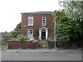
40 Sandy Lane
A Grade II listed house https://historicengland.org.uk/listing/the-list/list-entry/1356880?section=official-list-entry in need of some TLC.
Image: © Gerald England
Taken: 3 Sep 2022
0.03 miles
3
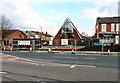
McDonald's & The Triangle Church
Looking up Clarendon Street to the rear of the Triangle Church Image and the McDonald's on the other side of Sandy Lane.
Image: © Gerald England
Taken: 26 Mar 2014
0.04 miles
4
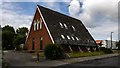
The Triangle Church
The Triangle Church off Sandy Lane was built in 1988 Image as the home of the Lancashire Hill Sunday School. It is used as a meeting place by various community groups.
Image: © Gerald England
Taken: 26 Mar 2014
0.04 miles
5
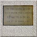
Triangle church foundation stone
The foundation stone of the Triangle Church Image reads:
TO THE GLORY OF GOD
THIS STONE WAS LAID BY
KENNETH G DEAN
ON 2nd OCTOBER 1988
Image: © Gerald England
Taken: 26 Mar 2014
0.04 miles
6
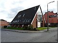
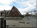
Triangle Church, Reddish
The Triangle Church off Sandy Lane was built in 1988 Image as the home of the Lancashire Hill Sunday School. It is used as a meeting place by various community groups. Behind it is George Ball & Son, funeral directors.
Image: © Gerald England
Taken: 26 Mar 2014
0.04 miles
7
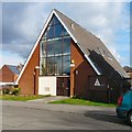
Triangle Church off Sandy Lane
The Triangle Church was built in 1988 as the home of the Lancashire Hill Sunday School. It is used as a meeting place by various community groups. To the right is George Ball & Son, funeral directors.
Image: © Gerald England
Taken: 26 Mar 2014
0.04 miles
8
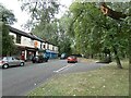
Sandy Lane
The top end of Sandy Lane. On the right is an underpass for pedestrians crossing Lancashire Hill. On the left is a computer engineers, the Roundabout Cafe and Stockport HGV training centre.
Image: © Gerald England
Taken: 3 Sep 2022
0.04 miles
9
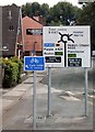
Signpost off Sandy Lane
Signpost on the B6167 approaching the junction with the A626 at the top of Lancashire Hill.
On the left is the Triangle church Image
Image: © Gerald England
Taken: 25 Jun 2016
0.04 miles
10
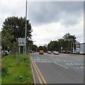
Sandy Lane
The B6167 from Reddish approaching Lancashire Hill. The A626 takes traffic left to Marple and the M60 at Portwood. To the right the B6167 carries on down to Stockport Town Centre while the A626 takes traffic to Heaton Chapel and the A6 for Manchester.
New mapping now shows the A626 through Heaton Chapel and Portwood as the A6188 but as yet there is no new signage indicating the change of number.
Image: © Gerald England
Taken: 15 Jun 2019
0.06 miles