IMAGES TAKEN NEAR TO
Greg Street, STOCKPORT, SK5 7NW
Introduction
This page details the photographs taken nearby to Greg Street, SK5 7NW by members of the Geograph project.
The Geograph project started in 2005 with the aim of publishing, organising and preserving representative images for every square kilometre of Great Britain, Ireland and the Isle of Man.

There are currently over 7.5m images from over14,400 individuals and you can help contribute to the project by visiting https://www.geograph.org.uk
Image Map
Images are licensed for reuse under creativecommons.org/licenses/by-sa/2.0
Notes
- Clicking on the map will re-center to the selected point.
- The higher the marker number, the further away the image location is from the centre of the postcode.
Image Listing (5 Images Found)
Images are licensed for reuse under creativecommons.org/licenses/by-sa/2.0
Image
Details
Distance
1
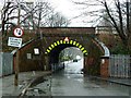
Low and narrow railway bridge
Photographed during a snowstorm.
Image: © Graham Hogg
Taken: 16 Dec 2011
0.22 miles
2
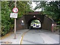
Road Narrows!
Looking east along Broadstone Hall Road near South Reddish. The bridge carries the railway line from Stockport to Stalybridge, via Guide Bridge. SJ89109266.
Image: © Keith Williamson
Taken: 18 Oct 2005
0.24 miles
3
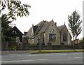
St Mary's, Reddish
St Mary, Reddish Road; (Church of England). Reddish's first church, built between 1862-1864 at a cost of £2500 in the "decorated English style" and consecrated on 23rd March 1865. The parish was created from Heaton Norris, and is still known as Heaton Reddish.
Image
Image: © Gerald England
Taken: 1 Sep 2012
0.25 miles
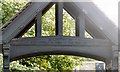
4
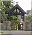
St Mary's Lychgate
Image: © Gerald England
Taken: 1 Sep 2012
0.25 miles
5
St Mary's Lychgate Inscription
The inscription on the lych gate Image reads:
In memory of Jonathan Schofield, father of the first rector's wife.
Image: © Gerald England
Taken: 1 Sep 2012
0.25 miles