IMAGES TAKEN NEAR TO
Erica Close, STOCKPORT, SK5 6YX
Introduction
This page details the photographs taken nearby to Erica Close, SK5 6YX by members of the Geograph project.
The Geograph project started in 2005 with the aim of publishing, organising and preserving representative images for every square kilometre of Great Britain, Ireland and the Isle of Man.

There are currently over 7.5m images from over14,400 individuals and you can help contribute to the project by visiting https://www.geograph.org.uk
Image Map
Images are licensed for reuse under creativecommons.org/licenses/by-sa/2.0
Notes
- Clicking on the map will re-center to the selected point.
- The higher the marker number, the further away the image location is from the centre of the postcode.
Image Listing (12 Images Found)
Images are licensed for reuse under creativecommons.org/licenses/by-sa/2.0
Image
Details
Distance
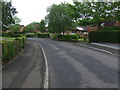
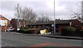
5
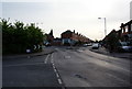
A staggered crossroads on Windmill Lane
Mill Lane joins from the left, while Longford Road leaves ahead.
Image: © Bill Boaden
Taken: 20 May 2010
0.20 miles
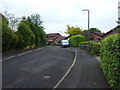
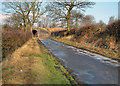
6

Windmill Lane
A long windy road from Denton into Reddish. This has been a route for a long time.
Image: © Bill Boaden
Taken: 20 May 2010
0.22 miles
7
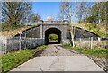
Mill Lane
Railway crossing Mill Lane.
Image: © Peter McDermott
Taken: 11 Apr 2021
0.22 miles
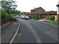
8
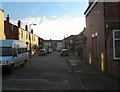
Tyrrel Road
From Longford Road towards Mill Lane.
Image: © Gerald England
Taken: 13 Jan 2012
0.22 miles
9
Giant`s Money Box
The bridge has a slot in the middle
Image: © Bob Abell
Taken: 17 Feb 2003
0.23 miles
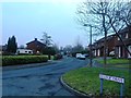
10
Reddish Police Station
Junction of Gorton Road and Mill Lane.
Image: © Peter Teal
Taken: 24 Feb 2010
0.23 miles