IMAGES TAKEN NEAR TO
Thornley Lane South, STOCKPORT, SK5 6QW
Introduction
This page details the photographs taken nearby to Thornley Lane South, SK5 6QW by members of the Geograph project.
The Geograph project started in 2005 with the aim of publishing, organising and preserving representative images for every square kilometre of Great Britain, Ireland and the Isle of Man.

There are currently over 7.5m images from over14,400 individuals and you can help contribute to the project by visiting https://www.geograph.org.uk
Image Map
Images are licensed for reuse under creativecommons.org/licenses/by-sa/2.0
Notes
- Clicking on the map will re-center to the selected point.
- The higher the marker number, the further away the image location is from the centre of the postcode.
Image Listing (45 Images Found)
Images are licensed for reuse under creativecommons.org/licenses/by-sa/2.0
Image
Details
Distance
1
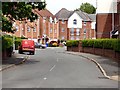
Cromwell Avenue
Off Thornley Lane South.
Image: © Gerald England
Taken: 17 May 2018
0.05 miles
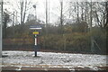
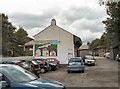
2
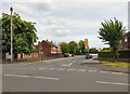
Thornley Lane South
Leading to Dane Bank Primary School (formerly Cromwell Special School).
Image: © Gerald England
Taken: 17 May 2018
0.06 miles
3
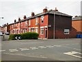
The corner of Wilton Street and Hobson Street
Image: © Gerald England
Taken: 17 May 2018
0.08 miles
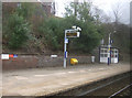
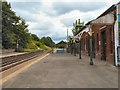
6
Reddish North Platform 1
The train is a Northern Rail service to Manchester Piccadilly.
Image: © Gerald England
Taken: 16 May 2015
0.12 miles
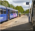
7

Boarding the Manchester Train
At Reddish North.
Image: © Gerald England
Taken: 16 May 2015
0.12 miles
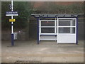
9
Reddish North Station
Looking towards Brinnington and Romiley.
Image: © Gerald England
Taken: 19 Jun 2009
0.13 miles
10
Reddish North Station
Looking rather more spruce and well used than it did in 1988 Image
Image: © Gerald England
Taken: 19 Jun 2009
0.13 miles