IMAGES TAKEN NEAR TO
Masefield Grove, STOCKPORT, SK5 6JA
Introduction
This page details the photographs taken nearby to Masefield Grove, SK5 6JA by members of the Geograph project.
The Geograph project started in 2005 with the aim of publishing, organising and preserving representative images for every square kilometre of Great Britain, Ireland and the Isle of Man.

There are currently over 7.5m images from over14,400 individuals and you can help contribute to the project by visiting https://www.geograph.org.uk
Image Map
Images are licensed for reuse under creativecommons.org/licenses/by-sa/2.0
Notes
- Clicking on the map will re-center to the selected point.
- The higher the marker number, the further away the image location is from the centre of the postcode.
Image Listing (5 Images Found)
Images are licensed for reuse under creativecommons.org/licenses/by-sa/2.0
Image
Details
Distance
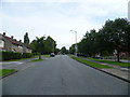
2
Reddish - Tennyson Avenue
Part of a sizable estate the roads of which are named after notable poets. Wordsworth Road is but a daffodil's stalk away while Chaucer Road needs not a pilgrim's progress.
Image: © Peter Whatley
Taken: 1 Apr 2009
0.16 miles
3
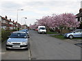
Reddish - Blossom Time on Wordsworth Road
Sorry - couldn't find a single daffodil, still less a host.
Image: © Peter Whatley
Taken: 1 Apr 2009
0.20 miles
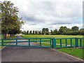
5
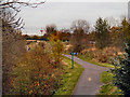
Fallowfield Loop Line
The disused railway line, now part of the National Cycle Network Route 6, looking north from Longford Road West.
Image: © David Dixon
Taken: 7 Nov 2012
0.24 miles