IMAGES TAKEN NEAR TO
Nelstrop Road, STOCKPORT, SK4 5NF
Introduction
This page details the photographs taken nearby to Nelstrop Road, SK4 5NF by members of the Geograph project.
The Geograph project started in 2005 with the aim of publishing, organising and preserving representative images for every square kilometre of Great Britain, Ireland and the Isle of Man.

There are currently over 7.5m images from over14,400 individuals and you can help contribute to the project by visiting https://www.geograph.org.uk
Image Map
Images are licensed for reuse under creativecommons.org/licenses/by-sa/2.0
Notes
- Clicking on the map will re-center to the selected point.
- The higher the marker number, the further away the image location is from the centre of the postcode.
Image Listing (32 Images Found)
Images are licensed for reuse under creativecommons.org/licenses/by-sa/2.0
Image
Details
Distance
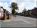
1
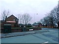
The end of Broadstone Hall Road North
Image: © Anthony Parkes
Taken: 12 Feb 2013
0.07 miles
2
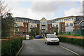
Adlington House
Retirement apartments off Nelstrop Road.
Image: © Bill Boaden
Taken: 10 Jan 2020
0.07 miles
3
Carnforth Road, Heaton Chapel
In the distance the Houldsworth Mill (1865) can be seen.
Image: © Geoff Royle
Taken: 1 Jun 2011
0.08 miles
4
Carnforth Road, Heaton Chapel
Winter clouds are providing some contrast. Houldsworth Mill is in the background.
Image: © Bill Boaden
Taken: 10 Jan 2020
0.09 miles
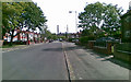
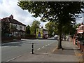
5
Broadstone Road
Broadstone Road looking Northeast, towards Reddish
Image: © Neil
Taken: 11 Sep 2007
0.18 miles
6
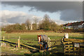
Paddock by Nelstrop Road
Viewed in low winter sun.
Image: © Bill Boaden
Taken: 10 Jan 2020
0.19 miles
7
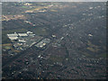
Heaton Chapel from the air
Crossley Park industrial estate is prominent on the left.
Image: © Thomas Nugent
Taken: 2 Apr 2013
0.19 miles
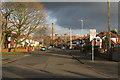
8
Broadstone Road, looking towards Heaton Chapel
Image: © Neil
Taken: 11 Sep 2007
0.20 miles
9
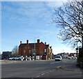
Wellington Road North, Heaton Chapel
The A6 through Heaton Chapel. On the left is the former Chapel House Hotel Image The original 1822 pub was rebuilt in 1889. It was purchased by Bass of Burton in 1921. It was later known as Tut n Shive, and then Conors until the police closed it down around 2009. It subsequently became a Tesco Extra supermarket before being closed again in 2015. The road to the left was the A626 but was renumbered A6188 in 2019/20. However, neither the old nor new number appears on road signs. The signs only mention that it leads to the B5169 to Reddish.
Image: © Gerald England
Taken: 1 Feb 2021
0.22 miles
10
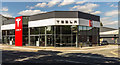
Tesla
The Tesla showroom on Stockport Road.
Image: © Peter McDermott
Taken: 6 Aug 2016
0.22 miles