IMAGES TAKEN NEAR TO
Merton Crescent, STOCKPORT, SK4 4SD
Introduction
This page details the photographs taken nearby to Merton Crescent, SK4 4SD by members of the Geograph project.
The Geograph project started in 2005 with the aim of publishing, organising and preserving representative images for every square kilometre of Great Britain, Ireland and the Isle of Man.

There are currently over 7.5m images from over14,400 individuals and you can help contribute to the project by visiting https://www.geograph.org.uk
Image Map
Images are licensed for reuse under creativecommons.org/licenses/by-sa/2.0
Notes
- Clicking on the map will re-center to the selected point.
- The higher the marker number, the further away the image location is from the centre of the postcode.
Image Listing (57 Images Found)
Images are licensed for reuse under creativecommons.org/licenses/by-sa/2.0
Image
Details
Distance
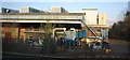
1
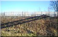
Railway cutting north of Heaton Chapel Station
Image: © N Chadwick
Taken: 18 Dec 2011
0.07 miles
2
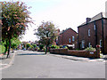
The end of Chandos Road, Stockport
The brief stretch of Chandos Road north of its junction with Alford Road.
Image: © Slbs
Taken: Unknown
0.09 miles
3
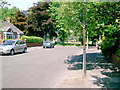
Alford Road, Stockport
Taken from the western end, this shot of Alford Road looks east towards the road's junction with Wellington Road North.
Image: © Slbs
Taken: Unknown
0.11 miles
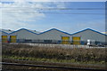
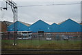
4
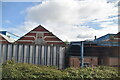
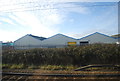
McVities Factory
A large food processing factory by the railway line.
Image: © N Chadwick
Taken: 2 Mar 2013
0.11 miles
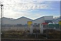
9
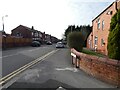
Alford Road
Off Wellington Road North.
Image: © Gerald England
Taken: 1 Feb 2021
0.15 miles