IMAGES TAKEN NEAR TO
Lower Bury Street, STOCKPORT, SK4 1BZ
Introduction
This page details the photographs taken nearby to Lower Bury Street, SK4 1BZ by members of the Geograph project.
The Geograph project started in 2005 with the aim of publishing, organising and preserving representative images for every square kilometre of Great Britain, Ireland and the Isle of Man.

There are currently over 7.5m images from over14,400 individuals and you can help contribute to the project by visiting https://www.geograph.org.uk
Image Map
Images are licensed for reuse under creativecommons.org/licenses/by-sa/2.0
Notes
- Clicking on the map will re-center to the selected point.
- The higher the marker number, the further away the image location is from the centre of the postcode.
Image Listing (154 Images Found)
Images are licensed for reuse under creativecommons.org/licenses/by-sa/2.0
Image
Details
Distance
1

Rooth Street
From the corner of Higher Bury Street and Lower Bury Street. The plane flying over is an Etihad Airlines plane Image en route to Manchester airport.
Image: © Gerald England
Taken: 31 Aug 2013
0.02 miles
2

Etihad Airliner over Stockport
An Etihad Airlines Airbus A330-200 en route for Manchester International Airport as it passes over Rooth Street Image
Image: © Gerald England
Taken: 31 Aug 2013
0.02 miles
3
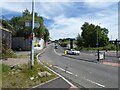
George's Road
Leading from Travis Brow to Wellington Road North. With a roundabout in the middle and a low bridge near the top it had been a nuisance for HGVs for many years. A new road solving the problem was constructed in 2019/20 Image
Image: © Gerald England
Taken: 4 Jun 2021
0.03 miles
4
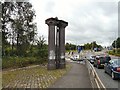
George's Road Columns
The junction of George's Road and Travis Brow. The columns on the left were supports for one of the bridges which carried railway lines onto the railway sidings that once existed here.
Image: © Gerald England
Taken: 10 Sep 2012
0.04 miles
5
George's Road
Leading from Travis Brow to Wellington Road North.
Image: © Gerald England
Taken: 8 Jul 2010
0.04 miles
6
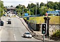
Travis Brow
By the junction with Georges Road.
Image: © Gerald England
Taken: 12 Mar 2022
0.04 miles
7
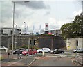
Travis Brow
The bottom of George's Road as it meets Travis Brow. A footpath leads to Lower Bury Street. Several car dealerships including Suzuki and Mazda can be seen. These are in the Green Lane Industrial Estate.
Image: © Gerald England
Taken: 21 Jul 2012
0.04 miles
8
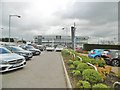
Stockport, RRG
Lexus & Mazda car dealership, on Green Lane Industrial Estate.
Image: © Mike Faherty
Taken: 9 Feb 2019
0.05 miles
9
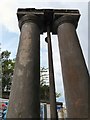
George's Road Columns
A look up the columns Image at the corner of Travis Brow and George's Road. They are all that remain of a railway bridge that once stood outside railway sidings that used to exist here.
Image: © Gerald England
Taken: 31 Aug 2013
0.05 miles
10
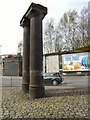
George's Road Columns
Two stone columns at the bottom of George's Road at Travis Brow. There is actually a metal pole in the middle of them not visible in this view. The columns can be seen from a different direction in Image I'm informed by Bill Ball who used to live on Travis Brow that they used to carry a railway bridge over George's Road to railway sidings.
Image: © Gerald England
Taken: 6 Apr 2011
0.05 miles