IMAGES TAKEN NEAR TO
Shaw Heath, STOCKPORT, SK3 9DY
Introduction
This page details the photographs taken nearby to Shaw Heath, SK3 9DY by members of the Geograph project.
The Geograph project started in 2005 with the aim of publishing, organising and preserving representative images for every square kilometre of Great Britain, Ireland and the Isle of Man.

There are currently over 7.5m images from over14,400 individuals and you can help contribute to the project by visiting https://www.geograph.org.uk
Image Map
Images are licensed for reuse under creativecommons.org/licenses/by-sa/2.0
Notes
- Clicking on the map will re-center to the selected point.
- The higher the marker number, the further away the image location is from the centre of the postcode.
Image Listing (614 Images Found)
Images are licensed for reuse under creativecommons.org/licenses/by-sa/2.0
Image
Details
Distance
1
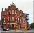
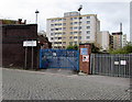
Blue Bell Hotel
Large hotel opposite the Edgeley entrance to Stockport Station. It has been closed for several years.
Image: © Gerald England
Taken: 31 Jul 2012
0.00 miles
2
Stockport - Blue Bell Hotel
For an alternative view, please see Image
Image: © Dave Bevis
Taken: 15 Jul 2015
0.00 miles
3
This way to the railway station and depot, Stockport
Station Road descends towards the entrance http://www.geograph.org.uk/photo/5116709 to the Network Railway Stockport Depot
and the western entrance http://www.geograph.org.uk/photo/5116705 to Stockport railway station.
Image: © Jaggery
Taken: 10 Sep 2016
0.01 miles
4
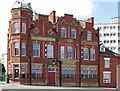
Former Blue Bell Hotel, Stockport
Viewed across Shaw Heath. Built in 1898 as the Blue Bell Hotel.
In September 2016 the building is Blue Bell Apartments.
Image: © Jaggery
Taken: 10 Sep 2016
0.02 miles
5
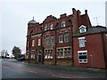
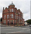
Blue Bell Hotel
Dated 1898, the Blue Bell Hotel on King Street West is now boarded up and derelict.
Image: © Gerald England
Taken: 8 Dec 2008
0.02 miles
6
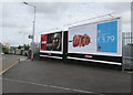
Primesight advertising hoardings, Shaw Heath, Stockport
Today displaying adverts for Aldi and Virgin, the hoardings face Shaw Heath near the Station Road junction.
Image: © Jaggery
Taken: 10 Sep 2016
0.02 miles
7
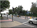
Shaw Heath pelican crossing, Stockport
Across Shaw Heath towards Our Lady's Catholic Primary School. http://www.geograph.org.uk/photo/5116746
Chambers Dictionary states that pelican in this context is adapted from "pedestrian light controlled crossing".
Image: © Jaggery
Taken: 10 Sep 2016
0.03 miles
8
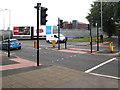
Shaw Heath pelican crossing, Stockport
Cross the road here for the railway footbridge http://www.geograph.org.uk/photo/5116751 towards the town centre.
Image: © Jaggery
Taken: 10 Sep 2016
0.03 miles
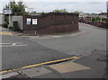
9
Entrance to the Network Railway Stockport Depot
From Station Road near the western entrance http://www.geograph.org.uk/photo/5116705 to Stockport railway station.
Image: © Jaggery
Taken: 10 Sep 2016
0.03 miles
10
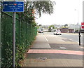
Cycle route direction and distances sign, Shaw Heath, Stockport
Use the adjacent pelican crossing http://www.geograph.org.uk/photo/5119036 for the town centre, railway station and Town Hall.
Image: © Jaggery
Taken: 10 Sep 2016
0.03 miles