1
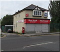
The Wash Father, Stockport
The Booth Street side of the car wash and tyre centre on the corner of Shaw Heath.
Image: © Jaggery
Taken: 10 Sep 2016
0.03 miles
2
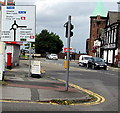
Directions sign on the approach to a roundabout near Stockport railway station
Facing the B5465 Shaw Heath.
Image: © Jaggery
Taken: 10 Sep 2016
0.03 miles
3
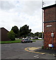
Booth Street, Stockport
Viewed from the B5465 Shaw Heath along Booth Street towards Mercian Way.
Mercian Way is also part of the course of the B5465.
Image: © Jaggery
Taken: 10 Sep 2016
0.04 miles
4
Railway towards Booth Street, Stockport
Viewed from the bridge on the corner of Mercian Way and Shaw Heath
looking towards the Booth Street bridge 100 metres ahead.
Image: © Jaggery
Taken: 10 Sep 2016
0.04 miles
5
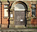
Welcome to edge hill Faculty of Health
"Welcome to edge hill Faculty of Health" says the sign on the doorway of the building once part of St Thomas' Hospital. "Press buzzer and wait for response" it says underneath but the building has been empty and derelict for some time
Image
Another sign on the door informs "Stockport Community Drugs Team is located around the corner of Flint Street".
Image: © Gerald England
Taken: 14 Jan 2014
0.04 miles
6
Older and newer Flint Street name signs, Stockport
On the corner of the B5465 Shaw Heath. Between the two name signs,
a police notice warns motorists not to leave valuables in their cars.
Image: © Jaggery
Taken: 10 Sep 2016
0.04 miles
7
Flint Street
In 2014 Flint Street
Image was a no through road. On the right is the derelict site of the former Stockport Workhouse
Image Part of the site, however, has been reclaimed and new houses have been built on Royal George Street.
Image: © Gerald England
Taken: 29 Sep 2018
0.04 miles
8
Former Shaw Heath Insurances office, Stockport
A For Sale board is on the premises in September 2016.
Image: © Jaggery
Taken: 10 Sep 2016
0.04 miles
9
Derelict Building on Shaw Heath
This building, part of Stockport Workhouse, was built in 1905 as a new office and board-room block and was erected at the west of the workhouse site at the corner of Flint Street.
It was used for a time by Edge Hill University as a Faculty of Health comprising several functions including teaching. It was also used by Stockport Community Alcohol Team as a drop in centre and needle exchange. Additionally it was a drop in centre for victims of domestic violence."
Image: © Gerald England
Taken: 29 Sep 2018
0.04 miles
10
Derelict former hospital building, Shaw Heath, Stockport
Viewed across the B5465 Shaw Heath in September 2016.
The building is part of the former St Thomas's Hospital which closed down in 2004.
Image: © Jaggery
Taken: 10 Sep 2016
0.04 miles


