IMAGES TAKEN NEAR TO
Culver Road, STOCKPORT, SK3 8PE
Introduction
This page details the photographs taken nearby to Culver Road, SK3 8PE by members of the Geograph project.
The Geograph project started in 2005 with the aim of publishing, organising and preserving representative images for every square kilometre of Great Britain, Ireland and the Isle of Man.

There are currently over 7.5m images from over14,400 individuals and you can help contribute to the project by visiting https://www.geograph.org.uk
Image Map
Images are licensed for reuse under creativecommons.org/licenses/by-sa/2.0
Notes
- Clicking on the map will re-center to the selected point.
- The higher the marker number, the further away the image location is from the centre of the postcode.
Image Listing (17 Images Found)
Images are licensed for reuse under creativecommons.org/licenses/by-sa/2.0
Image
Details
Distance
2
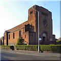
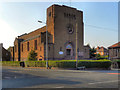
St Ambrose Catholic Church, Adswood
The large church on the corner of Clover Avenue and Adswood Road.
Image: © David Dixon
Taken: 29 Sep 2011
0.10 miles
4
St Ambrose Catholic Church
On Adswood Road
Image: © Gerald England
Taken: 14 Apr 2010
0.11 miles
8
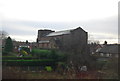
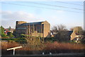
Garner's Lane
Leading from Adswood to Davenport.
Image: © Gerald England
Taken: 14 Apr 2010
0.15 miles
9
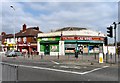
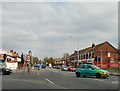
Adswood Shops
Shops on Adswood Road at the corner of Garner's Lane.
Image: © Gerald England
Taken: 14 Apr 2010
0.15 miles
10
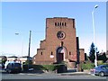
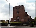
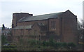
St.Ambrose
Catholic Church at Adswood, Stockport. Interestingly, it states on the noticeboard by the front door that it is in the Diocese of SHREWSBURY. Stockport is some 70 miles from Shrewsbury.
Image: © Roger May
Taken: 13 Nov 2005
0.15 miles