IMAGES TAKEN NEAR TO
Baguley Crescent, STOCKPORT, SK3 8LZ
Introduction
This page details the photographs taken nearby to Baguley Crescent, SK3 8LZ by members of the Geograph project.
The Geograph project started in 2005 with the aim of publishing, organising and preserving representative images for every square kilometre of Great Britain, Ireland and the Isle of Man.

There are currently over 7.5m images from over14,400 individuals and you can help contribute to the project by visiting https://www.geograph.org.uk
Image Map
Images are licensed for reuse under creativecommons.org/licenses/by-sa/2.0
Notes
- Clicking on the map will re-center to the selected point.
- The higher the marker number, the further away the image location is from the centre of the postcode.
Image Listing (18 Images Found)
Images are licensed for reuse under creativecommons.org/licenses/by-sa/2.0
Image
Details
Distance
1
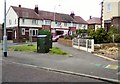
Baguley Crescent
Off Chelford Grove on the Bridgehall estate.
Image: © Gerald England
Taken: 8 Jun 2013
0.04 miles
2
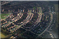
Adswood, Stockport, from the air
Taken from a plane on its approach to Manchester Airport.
Image: © Mike Pennington
Taken: 24 Feb 2017
0.07 miles
3
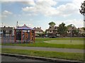
Bridgehall Playground
Playground on the Bridgehall estate.
Image: © Gerald England
Taken: 8 Jun 2013
0.07 miles
4
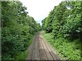
Railway towards Chester
On the route from Stockport to Chester via Altrincham seen from a footbridge off Petersburg Road
Image: © Kevin Waterhouse
Taken: 11 Jun 2024
0.16 miles
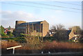
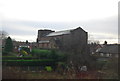
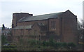
5
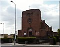
St Ambrose Catholic Church
On Adswood Road
Image: © Gerald England
Taken: 14 Apr 2010
0.20 miles