IMAGES TAKEN NEAR TO
Lowfield Road, STOCKPORT, SK3 8JR
Introduction
This page details the photographs taken nearby to Lowfield Road, SK3 8JR by members of the Geograph project.
The Geograph project started in 2005 with the aim of publishing, organising and preserving representative images for every square kilometre of Great Britain, Ireland and the Isle of Man.

There are currently over 7.5m images from over14,400 individuals and you can help contribute to the project by visiting https://www.geograph.org.uk
Image Map
Images are licensed for reuse under creativecommons.org/licenses/by-sa/2.0
Notes
- Clicking on the map will re-center to the selected point.
- The higher the marker number, the further away the image location is from the centre of the postcode.
Image Listing (118 Images Found)
Images are licensed for reuse under creativecommons.org/licenses/by-sa/2.0
Image
Details
Distance
1
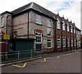
Zigzag yellow markings on Shaw Road South, Stockport
Marking the Keep Clear Zone outside Cale Green Primary School.
The sign on the left shows No stopping on the markings from 8am-5pm on Mondays-Fridays.
Image: © Jaggery
Taken: 10 Sep 2016
0.05 miles
2
Broadhurst Street Stockport
From the corner of Shaw Road South.
Image: © Jaggery
Taken: 10 Sep 2016
0.07 miles
3
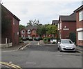
School Court, Meyer Street, Cale Green, Stockport
Managed by Anchor, School Court is sheltered housing containing 14 flats built in 1991, for people aged at least 55.
Image: © Jaggery
Taken: 10 Sep 2016
0.07 miles
4
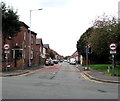
Lowfield Road, Stockport
Viewed across Shaw Heath looking along Lowfield Road towards Broadhurst Street.
Signs shows no vehicles heavier than 3.5 tonnes except for access.
Image: © Jaggery
Taken: 10 Sep 2016
0.08 miles
5
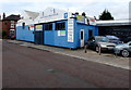
Range Garage Services, Stockport
Located in Peterlea Works, Shaw Road South.
Image: © Jaggery
Taken: 10 Sep 2016
0.09 miles
6
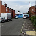
Green Street, Stockport
Looking towards Range Garage Services http://www.geograph.org.uk/photo/5160608 in Shaw Road South.
Image: © Jaggery
Taken: 10 Sep 2016
0.09 miles
7
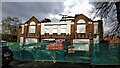
The Adswood Hotel
Demolition of the Adswood Hotel, Adswood Lane, Stockport
Image: © Paul Foster
Taken: 5 Dec 2021
0.09 miles
8
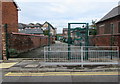
Entrance gate to Cale Green Primary School, Stockport
From Meyer Street.
Image: © Jaggery
Taken: 10 Sep 2016
0.10 miles
9
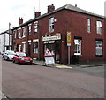
Shaw Road Chippy, Stockport
Fish and chips takeaway at 7 Shaw Road South, on the corner of Green Street.
Image: © Jaggery
Taken: 10 Sep 2016
0.10 miles
10
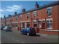
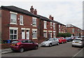
Edwardian Terrace at Ladysmith Street, Shaw Heath, Stockport
The image shows a fine example of the typical Victorian and Edwardian terraces that are a feature of the grid square, in this case benefiting from a recent sprucing-up by the Local Authority.
This street and the neighbouring Kimberley Street were built shortly after the conclusion of the Boer war, and the street would have been named after the 'Relief of Ladysmith' in 1900 (which preceded by a few months the much more famous 'Relief of Mafeking').
Image: © Tim Stuart
Taken: 10 Jun 2008
0.10 miles