1
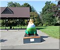
Resilience Frog
Located in Cale Green Park, Resilience Frog represents Davenport and Cale Green Ward. Sponsored by Stephensons it is one of 17 frogs taking up residence in wards across Stockport Borough in addition to the 21 frogs across the town centre. as part of Stockport's Gigantic Leap Frog Art Trail.
Image: © Gerald England
Taken: 7 Sep 2021
0.07 miles
2
Stockport Cricket Club
Early morning photograph of the bowling green and pitch of Stockport Cricket Club. The memorial column on the left lists the name of club members who lost their lives in the two world wars. The light mist obscures the view of Alderley Edge escarpment in the distance.
Image: © Gethin Evans
Taken: 24 Aug 2007
0.09 miles
3
The Adswood Hotel
Demolition of the Adswood Hotel, Adswood Lane, Stockport
Image: © Paul Foster
Taken: 5 Dec 2021
0.10 miles
4
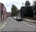
Lytham Street, Stockport
Looking south from Meyer Street.
Image: © Jaggery
Taken: 10 Sep 2016
0.11 miles
5
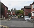
White houses, Adswood Lane West, Cale Green, Stockport
The house on the left is near the corner of Lytham Street.
Image: © Jaggery
Taken: 10 Sep 2016
0.11 miles
6
Adswood Lane West, Cale Green, Stockport
Adswood Lane East http://www.geograph.org.uk/photo/5125723 is behind the camera.
Image: © Jaggery
Taken: 10 Sep 2016
0.12 miles
7
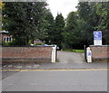
Evron Centre entrance, Adswood Lane West, Stockport
The Evron Centre is a small non-residential retreat and conference
centre owned and run by the Sisters of Charity of Our Lady of Evron.
Image: © Jaggery
Taken: 10 Sep 2016
0.13 miles
8
Travis Perkins entrance gates, Cale Green, Stockport
There are more than 600 branches of Travis Perkins builders merchants in the UK.
This one is accessed from Adswood Lane West in the Cale Green area of Stockport.
Image: © Jaggery
Taken: 10 Sep 2016
0.13 miles
9
School Court, Meyer Street, Cale Green, Stockport
Managed by Anchor, School Court is sheltered housing containing 14 flats built in 1991, for people aged at least 55.
Image: © Jaggery
Taken: 10 Sep 2016
0.13 miles
10
Junction of Beech Avenue and Cale Green, Stockport
The 20mph speed limit on Beech Avenue on the left increases to 30mph on Cale Green.
Image: © Jaggery
Taken: 10 Sep 2016
0.14 miles


