1
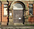
Derelict Building on Shaw Heath
This building, part of Stockport Workhouse, was built in 1905 as a new office and board-room block and was erected at the west of the workhouse site at the corner of Flint Street.
It was used for a time by Edge Hill University as a Faculty of Health comprising several functions including teaching. It was also used by Stockport Community Alcohol Team as a drop in centre and needle exchange. Additionally it was a drop in centre for victims of domestic violence."
Architectural detail:
Image
Doorway sign:
Image
Views of the inside can be found on the Derelict Places website http://www.derelictplaces.co.uk/main/showthread.php?t=24814#.UtgfdPRdVF4
Image: © Gerald England
Taken: 14 Jan 2014
0.01 miles
2
Union Office 1906
Detailed carving on the former Edge Hill Faculty of Health building
Image
Image: © Gerald England
Taken: 14 Jan 2014
0.01 miles
3
Our Lady's Social Club members' entrance, Stockport
From Flint Street. The top of Our Lady and the Apostles church http://www.geograph.org.uk/photo/5118873 is in the background.
Image: © Jaggery
Taken: 10 Sep 2016
0.01 miles
4
Welcome to edge hill Faculty of Health
"Welcome to edge hill Faculty of Health" says the sign on the doorway of the building once part of St Thomas' Hospital. "Press buzzer and wait for response" it says underneath but the building has been empty and derelict for some time
Image
Another sign on the door informs "Stockport Community Drugs Team is located around the corner of Flint Street".
Image: © Gerald England
Taken: 14 Jan 2014
0.02 miles
5
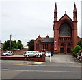
Roman Catholic Church of Our Lady & The Apostles
The Church of Our Lady and the Apostles was built in 1903-5 to replace an earlier church dedicated to SS Philip and James. It was designed by Edmund Kirby of Liverpool, the west front being similar to that of the Church of the Sacred Heart, Chorley by Kirby, 1894. In 1925 the sanctuary was redesigned as a First World War memorial with a new high altar backed by a cawed oak screen. Re-ordering of the church in circa 1989 saw the extension of this screen converting the sanctuary into an enclosed sanctuary chapel, with a new high altar, font and lectern placed before the chancel arch.
It is designated at Grade II http://maps.stockport.gov.uk/internet/gisshed/infopage.aspx?idno=478 for the following principal reasons: (1) Its architecturally impressive exterior, particularly the treatment of the west front facing Shaw Heath; (2) The high quality of its interior, both in terms of overall design and the detailing, especially the early C2O fittings; (3) The additional interest of later alterations such as the sanctuary chapel with its war memorial high altar and the eastern stained glass windows.
Church website: http://www.ourladyandtheapostles.co.uk/
Image: © Gerald England
Taken: 14 Jan 2014
0.02 miles
6
Our Lady and the Apostles church, Stockport
Roman Catholic Parish Church set back from the B5465 Shaw Heath, part of the Roman Catholic Diocese of Shrewsbury. Built in 1903-1905, Grade II listed in 2009.
Image: © Jaggery
Taken: 10 Sep 2016
0.02 miles
7
Our Lady and the Apostles church, Stockport
Roman Catholic Parish Church set back from the B5465 Shaw Heath, part of the Roman Catholic Diocese of Shrewsbury. Built in 1903-1905, Grade II listed in 2009.
Image: © Jaggery
Taken: 10 Sep 2016
0.02 miles
8
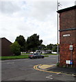
Flint Street
Off Shaw Heath. On the left is Our Lady and the Apostles Social Club. On the right are buildings previously belonging to St Thomas' Hospital. In the background is part of Stockport College.
Image: © Gerald England
Taken: 10 Feb 2014
0.02 miles
9
Older and newer Flint Street name signs, Stockport
On the corner of the B5465 Shaw Heath. Between the two name signs,
a police notice warns motorists not to leave valuables in their cars.
Image: © Jaggery
Taken: 10 Sep 2016
0.02 miles
10
Flint Street
In 2014 Flint Street
Image was a no through road. On the right is the derelict site of the former Stockport Workhouse
Image Part of the site, however, has been reclaimed and new houses have been built on Royal George Street.
Image: © Gerald England
Taken: 29 Sep 2018
0.02 miles


