IMAGES TAKEN NEAR TO
Algreave Road, STOCKPORT, SK3 0NH
Introduction
This page details the photographs taken nearby to Algreave Road, SK3 0NH by members of the Geograph project.
The Geograph project started in 2005 with the aim of publishing, organising and preserving representative images for every square kilometre of Great Britain, Ireland and the Isle of Man.

There are currently over 7.5m images from over14,400 individuals and you can help contribute to the project by visiting https://www.geograph.org.uk
Image Map
Images are licensed for reuse under creativecommons.org/licenses/by-sa/2.0
Notes
- Clicking on the map will re-center to the selected point.
- The higher the marker number, the further away the image location is from the centre of the postcode.
Image Listing (32 Images Found)
Images are licensed for reuse under creativecommons.org/licenses/by-sa/2.0
Image
Details
Distance
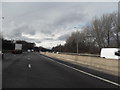
3
Rail Bridge Over The M60
Railway bridge crossing the M60 between junctions 2 and 1 (anti-clockwise).
Image: © David Dixon
Taken: 28 Aug 2010
0.14 miles
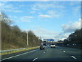
4
Go Outdoors, Cheadle
In weather like this, going outdoors isn't what you want to do. It isn't obviously apparent, but the depth of water in parts of the car park was a couple of inches, enough to wet any unsuspecting footwear.
Image: © Bill Boaden
Taken: 25 Aug 2012
0.17 miles
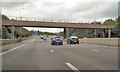
5
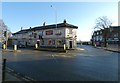
Stockport Road outside the Farmers Arms
The A560 outside the Farmers Arms Image at the junction with Edgeley Road (B5465).
Image: © Gerald England
Taken: 30 Dec 2019
0.17 miles
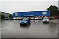
6
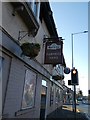
Farmers Arms
Currently a Greene King pub at the junction of Stockport Road and Edgeley Road.
Image: © Gerald England
Taken: 30 Dec 2019
0.18 miles
7
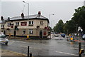
The Farmers Arms, Cheadle Heath
A landmark pub on the corner of Edgeley Road and Stockport Road. Edgeley Road has a large puddle on it.
Image: © Bill Boaden
Taken: 25 Aug 2012
0.18 miles
8
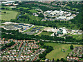
Cheadle sewage works from the air
On approach to Manchester Airport from the north east.
See also Image
Image: © Thomas Nugent
Taken: 13 Jun 2014
0.18 miles
9
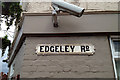
Cast iron street nameplate, Edgeley Road, Cheadle Heath
Notice that the plate is fixed with clips hammered into the mortar joints. This is on the Edgeley Road frontage of the Farmers Arms pub. A twentieth-century evocation of the traditional nameplates is seen in Image: it is screwed to the wall.
Image: © Robin Stott
Taken: 17 Aug 2013
0.19 miles
10
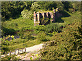
Mersey Vale Nature Park, Bridge Remains
Remains of the huge railway bridge that diagonally spanned the River Mersey. The line carried trains between Liverpool or Warrington and Stockport and was originally operated by the Cheshire Lines Committee, a partnership of the Great Central, Great Northern and Midland Railway companies.
Image: © Peter Fuller
Taken: 15 Jun 2010
0.19 miles