IMAGES TAKEN NEAR TO
Daw Bank, STOCKPORT, SK3 0EQ
Introduction
This page details the photographs taken nearby to Daw Bank, SK3 0EQ by members of the Geograph project.
The Geograph project started in 2005 with the aim of publishing, organising and preserving representative images for every square kilometre of Great Britain, Ireland and the Isle of Man.

There are currently over 7.5m images from over14,400 individuals and you can help contribute to the project by visiting https://www.geograph.org.uk
Image Map
Images are licensed for reuse under creativecommons.org/licenses/by-sa/2.0
Notes
- Clicking on the map will re-center to the selected point.
- The higher the marker number, the further away the image location is from the centre of the postcode.
Image Listing (973 Images Found)
Images are licensed for reuse under creativecommons.org/licenses/by-sa/2.0
Image
Details
Distance
1
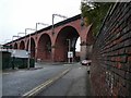
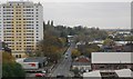
Viaduct Street
Stockport's famous railway viaduct was built in 1839/40 by the engineer George Watson Buck under the architect John Lowe. In 1887-89 it was widened to four tracks, 27 arches, 111 feet high and 1786 feet long, comprising 11 million bricks.
The road under this arch is Daw Bank.
Image: © Gerald England
Taken: 8 Dec 2008
0.01 miles
3
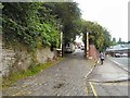
Stockport - south end of railway viaduct
As viewed from Platform 0 at Stockport Station. For an alternative view, please see Image
Image: © Dave Bevis
Taken: 15 Jul 2015
0.03 miles
4
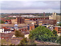
Railway Viaduct and Hat Museum
Two icons of Stockport, the great railway viaduct running across the top half of the picture and, in front of it, the mill which now houses the hat museum with its distinctive chimney.
Image: © David Dixon
Taken: 20 Jul 2010
0.03 miles
6
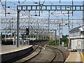
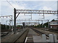
Stockport railway viaduct
Looking north towards Manchester from the platform-end at Stockport station.
Image: © Nigel Thompson
Taken: 23 Apr 2010
0.03 miles
7
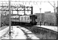
Class 150/2 at Stockport, 1989
A Class 150 diesel multiple unit No 150204 bound for Buxton arrives at Stockport station in the summer of 1989. Note the disused platforms in the foreground.
Image: © Rob Newman
Taken: 12 Aug 1989
0.04 miles
8
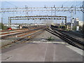
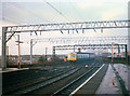
Railway north of Stockport railway station
The next station ahead is Heaton Chapel, for local stopping trains.
For other trains, such as the Virgin Pendolino http://www.geograph.org.uk/photo/5326936 from London Euston,
the next stop ahead is Manchester Piccadilly station.
Image: © Jaggery
Taken: 10 Sep 2016
0.04 miles

10
The Stalybridge shuttle at Stockport
This is the southern end of what was in its day a well-used link between the main lines into Piccadilly (at Stockport) and Victoria (at Stalybridge). The diesel unit is just leaving the station and passing onto the viaduct.
For a photo of the other end of the shuttle service see Image
Image: © Stephen Craven
Taken: 6 Feb 1988
0.04 miles