IMAGES TAKEN NEAR TO
Irving Close, STOCKPORT, SK2 7DX
Introduction
This page details the photographs taken nearby to Irving Close, SK2 7DX by members of the Geograph project.
The Geograph project started in 2005 with the aim of publishing, organising and preserving representative images for every square kilometre of Great Britain, Ireland and the Isle of Man.

There are currently over 7.5m images from over14,400 individuals and you can help contribute to the project by visiting https://www.geograph.org.uk
Image Map
Images are licensed for reuse under creativecommons.org/licenses/by-sa/2.0
Notes
- Clicking on the map will re-center to the selected point.
- The higher the marker number, the further away the image location is from the centre of the postcode.
Image Listing (9 Images Found)
Images are licensed for reuse under creativecommons.org/licenses/by-sa/2.0
Image
Details
Distance
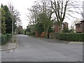
2
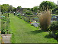
Flowery Fields Allotments, Woods Moor
Allotments close to Flowery Fields in Woodsmoor
Image: © Peter Fuller
Taken: 17 May 2010
0.18 miles
4
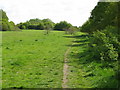
Mirrlees Fields, Woods Moor
View of the undeveloped Mirrlees Fields, next to the Mirrlees Diesel (now MAN-Diesel) factory where engines for trucks, ships and machines were made and can still be found worldwide.
Image: © Peter Fuller
Taken: 17 May 2010
0.22 miles
5
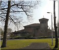
Trinity Methodist Church
Off Bramhall Lane South, Davenport.
Image: © Gerald England
Taken: 17 Mar 2011
0.22 miles
6
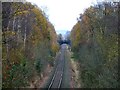
Single track railway through Davenport
The railway appears to be in regular use but it is not clear from the map what purpose it serves as there are no stations or industrial premises nearby.
Image: © Graham Hogg
Taken: 30 Nov 2011
0.22 miles
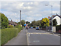
8
Woodsmoor Roundabout
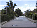
Approaching Woodsmoor roundabout on the A5102 Bramhall Lane through Davenport.
Image: © Gerald England
Taken: 17 Mar 2011
0.24 miles
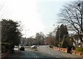
9
Davenport - The Crescent at Egerton Road
Image: © Peter Whatley
Taken: 25 Jan 2013
0.24 miles