IMAGES TAKEN NEAR TO
Wildflower Close, STOCKPORT, SK2 7DA
Introduction
This page details the photographs taken nearby to Wildflower Close, SK2 7DA by members of the Geograph project.
The Geograph project started in 2005 with the aim of publishing, organising and preserving representative images for every square kilometre of Great Britain, Ireland and the Isle of Man.

There are currently over 7.5m images from over14,400 individuals and you can help contribute to the project by visiting https://www.geograph.org.uk
Image Map
Images are licensed for reuse under creativecommons.org/licenses/by-sa/2.0
Notes
- Clicking on the map will re-center to the selected point.
- The higher the marker number, the further away the image location is from the centre of the postcode.
Image Listing (4 Images Found)
Images are licensed for reuse under creativecommons.org/licenses/by-sa/2.0
Image
Details
Distance
1
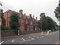
Cherry Tree Hospital
The Cherry Tree Hospital at the junction of Cherry Tree Lane and Dialstone Lane, Stockport Great Moor at SJ913884
Image: © Alan Fleming
Taken: 31 Aug 2005
0.05 miles
2
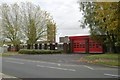
Offerton fire station
Offerton fire station, Lisburne Lane, Offerton, Stockport, Greater Manchester
Image: © Kevin Hale
Taken: 30 Oct 2007
0.13 miles