IMAGES TAKEN NEAR TO
Longshut Lane West, STOCKPORT, SK2 6RX
Introduction
This page details the photographs taken nearby to Longshut Lane West, SK2 6RX by members of the Geograph project.
The Geograph project started in 2005 with the aim of publishing, organising and preserving representative images for every square kilometre of Great Britain, Ireland and the Isle of Man.

There are currently over 7.5m images from over14,400 individuals and you can help contribute to the project by visiting https://www.geograph.org.uk
Image Map
Images are licensed for reuse under creativecommons.org/licenses/by-sa/2.0
Notes
- Clicking on the map will re-center to the selected point.
- The higher the marker number, the further away the image location is from the centre of the postcode.
Image Listing (247 Images Found)
Images are licensed for reuse under creativecommons.org/licenses/by-sa/2.0
Image
Details
Distance
1
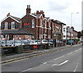
Stockport Motor Car Sales, Stockport
At 24 Longshut Lane West on the corner of Junction Road.
Image: © Jaggery
Taken: 10 Sep 2016
0.02 miles
2
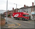
Longshut Lane West
The B5465 between Shaw Heath and Wellington Road South. The red lorry belonging to AAH pharmaceuticals was delivering to Lloyds Pharmacy Image
Image: © Gerald England
Taken: 24 Feb 2014
0.02 miles
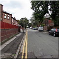
3
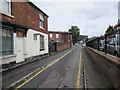
Junction Road, Stockport
Narrow road on the northeast side of Longshut Lane West.
Image: © Jaggery
Taken: 10 Sep 2016
0.03 miles
4
Junction Road
Leading off from the junction of Shaw Heath and Longshut Lane West.
Image: © Gerald England
Taken: 10 Feb 2014
0.03 miles
5
Derelict shop on a Stockport corner
The Junction Road side of the derelict shop on the corner of the B5465 Shaw Heath.
Image: © Jaggery
Taken: 10 Sep 2016
0.04 miles
6
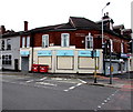
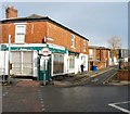
Lloyds Pharmacy, Longshut Lane West, Stockport
At 43-45 Longshut Lane West, on the corner of the B5465 Shaw Heath.
Image: © Jaggery
Taken: 10 Sep 2016
0.05 miles
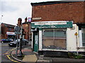
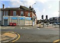
7
Junction of Shaw Heath and Longshut Road West
The Lloyds Pharmacy on the corner has now closed.
Image: © Gerald England
Taken: 29 Sep 2018
0.05 miles
8
Lyme Grove, Shaw Heath, Stockport
On the east side of the road named Shaw Heath in the Shaw Heath area of Stockport.
Image: © Jaggery
Taken: 10 Sep 2016
0.05 miles
9
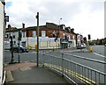
Shaw Heath Junction
Viewed from Junction Street. The B5465 comes in from the left as Longshut Lane West to meet Shaw Heath. The B road goes right to Edgeley while Shaw Heath to left (ahead as we are looking) continues unclassified to Cale Green.
Image: © Gerald England
Taken: 22 Aug 2015
0.05 miles
10
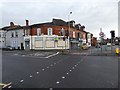
Corner of Longshut Lane West and Shaw Heath
Until recently maps and signs have the B5465 coming in from the left as Longshut Lane West to meet Shaw Heath. The B5465 road turns right to Edgeley while Shaw Heath on the left continues unclassified to Cale Green.
Recent online mapping however shows the B5465 applied to the previously unclassified Greek Street and Waterloo Road from Edgeley to the A626 (A6188) on St Mary's Way. Shaw Heath appears to have been given the designation B6184 continuing through Cale Green until it meets the A5102. Longshut Lane West appears to be now unclassified. The road through Cale Green has a three and a half ton limit on lorries, except for access.
The boarded up shop on the corner used to be Lloyds pharmacy Image
Image: © Gerald England
Taken: 12 Nov 2019
0.05 miles