IMAGES TAKEN NEAR TO
Cale Green, STOCKPORT, SK2 6RD
Introduction
This page details the photographs taken nearby to Cale Green, SK2 6RD by members of the Geograph project.
The Geograph project started in 2005 with the aim of publishing, organising and preserving representative images for every square kilometre of Great Britain, Ireland and the Isle of Man.

There are currently over 7.5m images from over14,400 individuals and you can help contribute to the project by visiting https://www.geograph.org.uk
Image Map
Images are licensed for reuse under creativecommons.org/licenses/by-sa/2.0
Notes
- Clicking on the map will re-center to the selected point.
- The higher the marker number, the further away the image location is from the centre of the postcode.
Image Listing (106 Images Found)
Images are licensed for reuse under creativecommons.org/licenses/by-sa/2.0
Image
Details
Distance
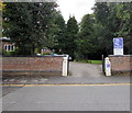
1
Telecoms cabinets near the entrance to Heathfield House, Stockport
On the east side of Cale Green. Heathfield House is a National Health Service site.
Image: © Jaggery
Taken: 10 Sep 2016
0.01 miles
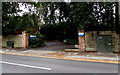
2
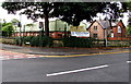
Evron Centre entrance, Adswood Lane West, Stockport
The Evron Centre is a small non-residential retreat and conference
centre owned and run by the Sisters of Charity of Our Lady of Evron.
Image: © Jaggery
Taken: 10 Sep 2016
0.03 miles
3
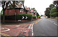
Junction of Beech Avenue and Cale Green, Stockport
The 20mph speed limit on Beech Avenue on the left increases to 30mph on Cale Green.
Image: © Jaggery
Taken: 10 Sep 2016
0.04 miles
4
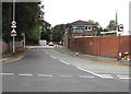
Adswood Lane West, Cale Green, Stockport
Adswood Lane East http://www.geograph.org.uk/photo/5125723 is behind the camera.
Image: © Jaggery
Taken: 10 Sep 2016
0.05 miles
5
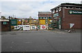
Travis Perkins entrance gates, Cale Green, Stockport
There are more than 600 branches of Travis Perkins builders merchants in the UK.
This one is accessed from Adswood Lane West in the Cale Green area of Stockport.
Image: © Jaggery
Taken: 10 Sep 2016
0.05 miles
6
Northeast corner of Hillcrest Grammar School, Stockport
This is the corner of Heath Road and Beech Avenue. The white banner on display on September 10th 2016
shows that Stockport Lacrosse Club is recruiting boys and girls in the 8-16 age groups.
Image: © Jaggery
Taken: 10 Sep 2016
0.05 miles
7
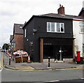
Aruba House, Stockport
Business premises on the corner of Adswood Lane East and Shaw Heath.
Image: © Jaggery
Taken: 10 Sep 2016
0.05 miles
8

King George V pillarbox and its reflection, Stockport
A window of Aruba House http://www.geograph.org.uk/photo/5125770 reflects the pillarbox on the Adswood Lane East pavement.
Image: © Jaggery
Taken: 10 Sep 2016
0.05 miles
9
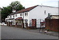
White houses, Adswood Lane West, Cale Green, Stockport
The house on the left is near the corner of Lytham Street.
Image: © Jaggery
Taken: 10 Sep 2016
0.06 miles
10
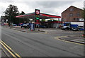
Texaco filling station, Cale Green, Stockport
The filling station is on the corner of Shaw Heath and Meyer Street.
On September 16th 2016, unleaded petrol is 112.9 pence per litre. Diesel is 114.9 pence per litre.
Image: © Jaggery
Taken: 10 Sep 2016
0.07 miles