IMAGES TAKEN NEAR TO
Beverley Road, STOCKPORT, SK2 5AY
Introduction
This page details the photographs taken nearby to Beverley Road, SK2 5AY by members of the Geograph project.
The Geograph project started in 2005 with the aim of publishing, organising and preserving representative images for every square kilometre of Great Britain, Ireland and the Isle of Man.

There are currently over 7.5m images from over14,400 individuals and you can help contribute to the project by visiting https://www.geograph.org.uk
Image Map
Images are licensed for reuse under creativecommons.org/licenses/by-sa/2.0
Notes
- Clicking on the map will re-center to the selected point.
- The higher the marker number, the further away the image location is from the centre of the postcode.
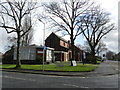
Image Listing (7 Images Found)
Images are licensed for reuse under creativecommons.org/licenses/by-sa/2.0
Image
Details
Distance
1
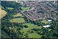
Woodbank Park, Stockport, from the air
Image: © Mike Pennington
Taken: 24 Aug 2018
0.18 miles
2
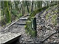
Muddy steps beside a moss-covered fence
On the Midshires Way beside the River Goyt
Image: © Graham Hogg
Taken: 3 Jan 2022
0.20 miles
3
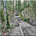
Stepping up
Through the mud of the Midshires Way
Image: © Chris Morgan
Taken: 3 Jan 2022
0.21 miles
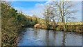
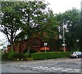
7
The Strawberry Gardens
A fruitily named pub on Offerton Lane, near the junction with Woodlands Drive.
Image: © Peter Barr
Taken: 15 Feb 2013
0.24 miles