IMAGES TAKEN NEAR TO
Combs, HIGH PEAK, SK23 9UX
Introduction
This page details the photographs taken nearby to SK23 9UX by members of the Geograph project.
The Geograph project started in 2005 with the aim of publishing, organising and preserving representative images for every square kilometre of Great Britain, Ireland and the Isle of Man.

There are currently over 7.5m images from over14,400 individuals and you can help contribute to the project by visiting https://www.geograph.org.uk
Image Map (Loading...)


Getting Data...Please wait
Leaflet Map data © OpenStreetMap
Images are licensed for reuse under creativecommons.org/licenses/by-sa/2.0
Notes
- Clicking on the map will re-center to the selected point.
- The higher the marker number, the further away the image location is from the centre of the postcode.
Image Listing (17 Images Found)
Images are licensed for reuse under creativecommons.org/licenses/by-sa/2.0
Image
Details
Distance
1
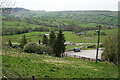
Hillside above Whitehills Farm
Looking down to Combs in the valley of Meveril Brook.
Image: © Bill Boaden
Taken: 20 Apr 2022
0.02 miles
2
Uphill to Whitehills
Converted farmhouses near Combs, Derbyshire.
Image: © Peter Barr
Taken: 31 Aug 2010
0.07 miles
3
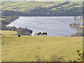
Combs Reservoir from Whitehills
From Cowlow Lane, SK048785.
Image: © Dave Dunford
Taken: 16 Apr 2006
0.08 miles
4
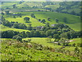
Combs valley, Derbyshire
From the lane from Whitehills towards Dove Holes.
Image: © Peter Barr
Taken: 31 Aug 2010
0.09 miles
5
Flowering Gorse on Cowlow Lane
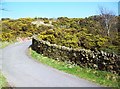
Coconut-scented Common Gorse seen here flourishing by the roadside near Combs.
Image: © Jonathan Clitheroe
Taken: 24 Mar 2012
0.10 miles
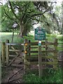
6
Peak & Northern Footpaths Society, Sign No 185
In memory of David Bellhouse, dedicated by his wife Peggy
Image: © Philip Cornwall
Taken: 4 Sep 2021
0.19 miles
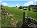
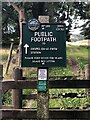
7
Path northwards from Rye Flatt
It leads eventually to Chapel-en-le-Frith railway station.
Image: © Neil Theasby
Taken: 2 Jul 2014
0.20 miles
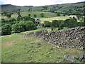
10
Footpath to Chapel-en-le-Frith
Leaving Ridge Lane near Combs. The profile of Castle Naze is seen top right.
Image: © Bill Boaden
Taken: 20 Apr 2022
0.21 miles