IMAGES TAKEN NEAR TO
Crossings Road, HIGH PEAK, SK23 9RZ
Introduction
This page details the photographs taken nearby to Crossings Road, SK23 9RZ by members of the Geograph project.
The Geograph project started in 2005 with the aim of publishing, organising and preserving representative images for every square kilometre of Great Britain, Ireland and the Isle of Man.

There are currently over 7.5m images from over14,400 individuals and you can help contribute to the project by visiting https://www.geograph.org.uk
Image Map
Images are licensed for reuse under creativecommons.org/licenses/by-sa/2.0
Notes
- Clicking on the map will re-center to the selected point.
- The higher the marker number, the further away the image location is from the centre of the postcode.
Image Listing (9 Images Found)
Images are licensed for reuse under creativecommons.org/licenses/by-sa/2.0
Image
Details
Distance
2

Police Station, Chapel-en-le-Frith
Disguised as a semi detached house with a blue door.
Image: © Peter Barr
Taken: 17 Mar 2014
0.17 miles
3
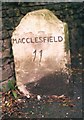
Old Milestone by the B5470, Manchester Road, Lower Crossing
Carved stone post by the B5470, in parish of CHAPEL EN LE FRITH (HIGH PEAK District), Lower Crossing, one mile West of Townend, in tarmac path in front of dry stone wall, on South side of road. Chapel Wedge, erected by the Macclesfield to Chapel en le Frith turnpike trust in the 18th century.
Inscription reads:-
: MACCLESFIELD / 11 : : CHESTERFIELD / 23 :
Milestone Society National ID: DE_CFMF23.
Image: © J Higgins
Taken: 1 May 2002
0.18 miles
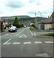
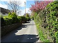
4
Lower Crossings
Looking ENE along the B5470 towards Chapel-en-le-Frith from the entrance to Marsh Hall
Image: © Dave Dunford
Taken: 4 Dec 2005
0.19 miles
5
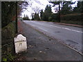
Milestone, B5470
From the entrance to Marsh Hall looking west.
Image: © Dave Dunford
Taken: 4 Dec 2005
0.19 miles
6
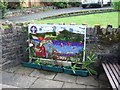
Nanny's Well decorated for the 2009 season
The theme for the well-dressing was the centenary of the 1st Chapel Scouts
Image: © David Smith
Taken: 5 Jul 2009
0.19 miles
8
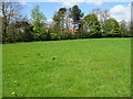
Farmland at Frith Knoll
The house at Frith Knoll was used as an auxiliary hospital during the Great War.
Image: © John M
Taken: 22 Apr 2017
0.22 miles
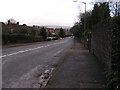
9
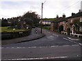
Higher Crossings
From the crossroads of Crossings Road with Eccles Road, looking west towards Eccles Pike.
Image: © Dave Dunford
Taken: 4 Dec 2005
0.25 miles