IMAGES TAKEN NEAR TO
Eccles Road, HIGH PEAK, SK23 9RS
Introduction
This page details the photographs taken nearby to Eccles Road, SK23 9RS by members of the Geograph project.
The Geograph project started in 2005 with the aim of publishing, organising and preserving representative images for every square kilometre of Great Britain, Ireland and the Isle of Man.

There are currently over 7.5m images from over14,400 individuals and you can help contribute to the project by visiting https://www.geograph.org.uk
Image Map (Loading...)


Getting Data...Please wait
Leaflet Map data © OpenStreetMap
Images are licensed for reuse under creativecommons.org/licenses/by-sa/2.0
Notes
- Clicking on the map will re-center to the selected point.
- The higher the marker number, the further away the image location is from the centre of the postcode.
Image Listing (21 Images Found)
Images are licensed for reuse under creativecommons.org/licenses/by-sa/2.0
Image
Details
Distance
1
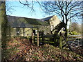
Signpost down at Lydgate
A post has collapsed under the weight of the ivy; Higher Crossings, Chapel-en-le-Frith. Old farm buildings.
Image: © Peter Barr
Taken: 19 Nov 2010
0.05 miles
2
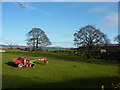
Farm with cultivator and Wendy House
The Wendy House may be for chickens; why shouldn't they have somewhere nice to live? As long as it's fox proof. At Digleach Far, Chapel-en-le-Frith.
Image: © Peter Barr
Taken: 19 Nov 2010
0.05 miles
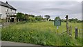
3
Higher Crossings
On the outskirts of Chapel-en-le-Frith
Image: © Graham Hogg
Taken: 17 Jun 2013
0.08 miles
4
Footpath to Eccles Pike at Higher Crossings
Image: © Chris Morgan
Taken: 17 Jun 2013
0.12 miles
5
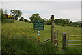
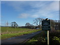
Foot Path sign
A well-marked footpath near Eccles Pike.
Image: © Dave Pickersgill
Taken: 30 Oct 2013
0.12 miles
6
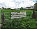
Neosporosis sign on a gate at Higher Crossings
Neosporosis, carried in dog faeces, can cause pregnant cows to spontaneously abort. I spoke to the creator of the sign who is the resident farmer at nearby Digleach Farm and he explained the worrisome issues with local dogwalkers.
See http://www.countryfile.com/news/neosporosis-hidden-danger-dogs-pose-cattle
Image: © Neil Theasby
Taken: 18 May 2017
0.12 miles
7
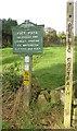
Peak & Northern Footpath Society sign no. 27
Erected in 1906, this is one of the earliest of the Society's signs.
Image: © Graham Hogg
Taken: 17 Jun 2013
0.13 miles
9
PNFS sign No. 39
Peak & Northern Footpaths sign at Lidgate, west of Lower Crossings, Chapel-en-le-Frith.
Image: © Peter Barr
Taken: 19 Nov 2010
0.15 miles
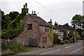
10
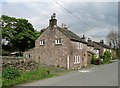
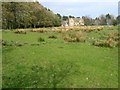
Cottages at Higher Crossings
On Eccles Road
Image: © Neil Theasby
Taken: 18 May 2017
0.15 miles