IMAGES TAKEN NEAR TO
Silk Hill, HIGH PEAK, SK23 7TA
Introduction
This page details the photographs taken nearby to Silk Hill, SK23 7TA by members of the Geograph project.
The Geograph project started in 2005 with the aim of publishing, organising and preserving representative images for every square kilometre of Great Britain, Ireland and the Isle of Man.

There are currently over 7.5m images from over14,400 individuals and you can help contribute to the project by visiting https://www.geograph.org.uk
Image Map
Images are licensed for reuse under creativecommons.org/licenses/by-sa/2.0
Notes
- Clicking on the map will re-center to the selected point.
- The higher the marker number, the further away the image location is from the centre of the postcode.
Image Listing (181 Images Found)
Images are licensed for reuse under creativecommons.org/licenses/by-sa/2.0
Image
Details
Distance
4
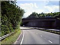
Bridge (Brookside) over the A6 at Buxworth
The Chapel-en-le-Frith /Whaley Bridge section of the A6 was bypassed in the 80s, with this four-mile long good dual carriageway which twists up the valley.
Image: © David Dixon
Taken: 4 Aug 2014
0.06 miles
5
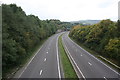
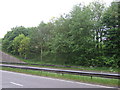
Westbound A6, Buxworth
From the footbridge above Bugsworth Basin. The overbridge in the distance carries a minor road.
Image: © Dave Dunford
Taken: 2 Oct 2014
0.06 miles
6
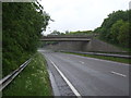
Brookside Bridge over the A6
Near Buxworth.
Image: © JThomas
Taken: 24 May 2014
0.07 miles
7
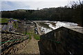
Buxworth Basin temporarily drained (4)
Repairs to embankments of the basin; due to re-open near Easter 2014.
Image: © Peter Barr
Taken: 19 Mar 2014
0.07 miles
8
Bugsworth Basin
The restoration of this historically important canal basin complex took place over many years and was plagued by problems with leaks in the canal bed before finally being reopened. In this 1981 view work on many of the remaining structures was well advanced although plenty remained to be done before the basin could be rewatered. Compare this picture with a similar view today Image
Image: © David Stowell
Taken: Unknown
0.08 miles
9
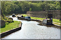
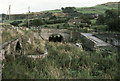
Bugsworth Basin
Being brought up in Nottingham I am quite familiar with the Derbyshire Peaks. Beyond Buxton however it was a mystery. I don’t recall ever being to New Mills or Whaley Bridge before. I was amazed to discover that at the end of the 18th century a canal was constructed through the steep sided valleys into the heart of the Peaks. Such a tremendous feat of engineering. The Peak Forest Canal was built to transport limestone, gritstone and coal to the factories and industries of the North West. Bugsworth Basin was one end of the canal and was once a hive of activity. The minerals and stone was brought down from the hills by horse drawn waggonways and loaded onto canal barges. At the height of working 2,000 barges full of limestone were exported each year.
Today the canal and basin have been restored providing a rare opportunity in these parts for level walking and cycling along the towpath.
Image: © Mick Garratt
Taken: 15 May 2016
0.09 miles
10
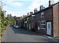
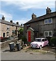
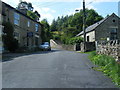
Western Lane in Buxworth
Pictured here close to Silk Hill which is situated behind the photographer position.
Image: © Jonathan Clitheroe
Taken: 15 Sep 2012
0.10 miles