IMAGES TAKEN NEAR TO
Hockerley Avenue, HIGH PEAK, SK23 7RT
Introduction
This page details the photographs taken nearby to Hockerley Avenue, SK23 7RT by members of the Geograph project.
The Geograph project started in 2005 with the aim of publishing, organising and preserving representative images for every square kilometre of Great Britain, Ireland and the Isle of Man.

There are currently over 7.5m images from over14,400 individuals and you can help contribute to the project by visiting https://www.geograph.org.uk
Image Map
Images are licensed for reuse under creativecommons.org/licenses/by-sa/2.0
Notes
- Clicking on the map will re-center to the selected point.
- The higher the marker number, the further away the image location is from the centre of the postcode.
Image Listing (6 Images Found)
Images are licensed for reuse under creativecommons.org/licenses/by-sa/2.0
Image
Details
Distance
1
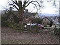
Hockerley
Like nearby Stoneheads, Hockerley is a satellite hamlet of Whaley Bridge, with some old dwellings, now encroached upon by modern housing.
Image: © Dave Dunford
Taken: 18 Dec 2005
0.03 miles
2
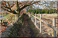
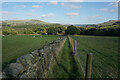
Footpath towards Hockerley
The footpath leads from a modern housing estate built on the western slopes above Whaley Bridge to the hamlet of Hockerley.
Image: © Bob Prophet
Taken: 23 Nov 2011
0.07 miles
3
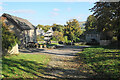
Hockerley
A small farming hamlet which is now on the outskirts of Whaley Bridge.
Image: © Bill Boaden
Taken: 13 Oct 2022
0.08 miles
4
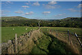
Footpath down to Bridgemont
The path comes down from Hockerley skirting round some smallholding plots to the right. The River Goyt is in the valley ahead.
Image: © Bill Boaden
Taken: 13 Oct 2022
0.16 miles
5
Footpath down to Bridgemont
The path comes from Hockerley and descends into the valley of the River Goyt.
Image: © Bill Boaden
Taken: 13 Oct 2022
0.20 miles
6
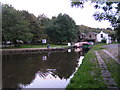
Whaley Bridge Canal Basin, Peak Forest Canal
The terminus of the Peak Forest Canal - goods were transshipped at this point to and from the High Peak Railway, which ran between the Peak Forest and Cromford Canals and closed in 1967.
Image: © Dave Dunford
Taken: 16 Sep 2005
0.24 miles