1
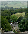
Across the rooftops to the fields, Whaley Bridge
This telephoto assisted image was taken from the station footbridge. The terraced houses are in Bingswood Avenue.
Image: © Roger D Kidd
Taken: 6 Sep 2014
0.01 miles
2
Whaley Bridge Canal Basin
Image: © BB
Taken: 30 May 2003
0.02 miles
3
One time railway bridge
Now a footbridge over the River Goyt.
Image: © philandju
Taken: 25 Oct 2018
0.03 miles
4
Whaley Bridge Basin
Information panel depicting life at the basin in the 1890's
Image: © Eirian Evans
Taken: 13 Jul 2014
0.03 miles
5
The Transhipment Warehouse, Whaley Bridge
This building dates from 1801 and was extended in 1832, serving the limit of the Peak Forest Canal in Whaley Bridge. Limestone from local quarries would have been loaded into boats here and general goods both loaded an unloaded - all with protection from the weather. Today the building has been repurposed as a craft skills centre. It is grade II* listed.
Image: © Stephen McKay
Taken: 17 Oct 2023
0.04 miles
6
Cromford and High Peak Railway bridge, Whaley Bridge
Originally a horse tramway linking the Peak Forest and Cromford Canals, it was later modernised for locomotive traction. This girder bridge survives as part of a footpath.
Image: © Alan Murray-Rust
Taken: 12 May 2006
0.04 miles
7
Transhipment Shed at Whaley Bridge Canal Basin
The shed was built to allow transfer of coal, limestone and cotton from rail to boat or vice versa. The centre arch is over the Peak Forest Canal and the two side arches covered the rails of the Cromford & High Peak Railway.
Image: © Eirian Evans
Taken: 13 Jul 2014
0.05 miles
8
Judith Mary II
The narrowboat, nicknamed "Pride of the Peak" recently returned its mooring in Whaley Bridge after an enforced evacuation
Image The Judith Mary is a family run 72 foot long canal boat which has been running for 36 years. It offers two-hour cruises up the Peak Forest Canal including a hot meal or a cream tea. Website: https://www.judithmary2.co.uk/
Image: © Gerald England
Taken: 19 Aug 2019
0.05 miles
9
Transhipment shed, Whaley Bridge
Dated 1832 and built to allow transfer of material from rail to boat or vice versa. The centre arch is over the Peak Forest Canal and the two side arches covered the rails of the Cromford & High Peak Railway. This is really early stuff.
Image: © Chris Allen
Taken: 15 Mar 2009
0.05 miles
10
Whaley Bridge - canal terminus and transhipment shed
Dated 1832 and built to allow transfer of material from rail to boat or vice versa. The centre arch is over the Peak Forest Canal and the two side arches covered the rails of the Cromford & High Peak Railway. This is really early stuff.
Image: © Chris Allen
Taken: 15 Mar 2009
0.05 miles


