IMAGES TAKEN NEAR TO
Caldene Terrace, HIGH PEAK, SK23 7HZ
Introduction
This page details the photographs taken nearby to Caldene Terrace, SK23 7HZ by members of the Geograph project.
The Geograph project started in 2005 with the aim of publishing, organising and preserving representative images for every square kilometre of Great Britain, Ireland and the Isle of Man.

There are currently over 7.5m images from over14,400 individuals and you can help contribute to the project by visiting https://www.geograph.org.uk
Image Map
Images are licensed for reuse under creativecommons.org/licenses/by-sa/2.0
Notes
- Clicking on the map will re-center to the selected point.
- The higher the marker number, the further away the image location is from the centre of the postcode.
Image Listing (154 Images Found)
Images are licensed for reuse under creativecommons.org/licenses/by-sa/2.0
Image
Details
Distance
1

Disused colliery air shaft, Whaley Bridge
This marks the site of an air shaft for the colliery that was located on the site of the present car park below old road. The windows date from its later use as storage premises.
Image: © Chris Allen
Taken: 15 Mar 2009
0.03 miles
2

T Coward & Sons, garage, Whaley Bridge
The tall structure in the background is a disused colliery air shaft for a colliery that was in what is now a car park below Old Road.
Image: © Chris Allen
Taken: 15 Mar 2009
0.03 miles
3
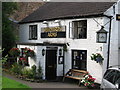
New Horwich - Shepherds Arms on Old Road
Image: © Dave Bevis
Taken: 13 Aug 2009
0.03 miles
4

Old Road, Whaley Bridge
On the corner of Bings Road.
Image: © Peter Barr
Taken: 17 Mar 2014
0.03 miles
5
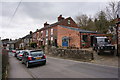
Old Road, Whaley Bridge, terraced houses
Image: © Peter Barr
Taken: 17 Mar 2014
0.03 miles
6
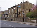
Whaley Bridge Uniting Church
Market Street
Image: © David Dixon
Taken: 18 Apr 2010
0.03 miles
7
Whaley Bridge Uniting Church
A Methodist chapel since 1821 now combined with United Reformed and Baptist church congregations.
Image: © Chris Morgan
Taken: 14 Jun 2017
0.03 miles
8
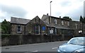
Uniting Church
The Grade II listed building https://historicengland.org.uk/listing/the-list/list-entry/1054734 was originally the Wesleyan Methodist Church and Sunday School. The central unit dates from 1821. The left hand wing is the chapel built in 1867. The right hand wing is the Sunday School. The building was revamped in 2011. A glazed link was constructed through which the original windows and stone work can be seen. The church is now made up of three denominations (Methodist, United Reformed and Baptist) worshipping together and is used by various community groups.
Image: © Gerald England
Taken: 19 Aug 2019
0.03 miles
9
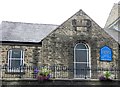
Wesleyan Chapel AD 1867
The left hand wing of the Uniting Church Image
Image: © Gerald England
Taken: 19 Aug 2019
0.03 miles
10
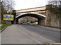
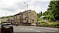
Whaley Bridge Railway Bridge
Buxton Road (A5004) passing under the railway at the southern end of Whaley Bridge. Image] can be seen through the bridge.
Image: © David Dixon
Taken: 18 Apr 2010
0.03 miles