IMAGES TAKEN NEAR TO
Kettleshulme, HIGH PEAK, SK23 7EH
Introduction
This page details the photographs taken nearby to SK23 7EH by members of the Geograph project.
The Geograph project started in 2005 with the aim of publishing, organising and preserving representative images for every square kilometre of Great Britain, Ireland and the Isle of Man.

There are currently over 7.5m images from over14,400 individuals and you can help contribute to the project by visiting https://www.geograph.org.uk
Image Map (Loading...)


Getting Data...Please wait
Leaflet Map data © OpenStreetMap
Images are licensed for reuse under creativecommons.org/licenses/by-sa/2.0
Notes
- Clicking on the map will re-center to the selected point.
- The higher the marker number, the further away the image location is from the centre of the postcode.
Image Listing (13 Images Found)
Images are licensed for reuse under creativecommons.org/licenses/by-sa/2.0
Image
Details
Distance
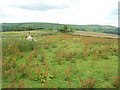
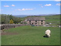
2
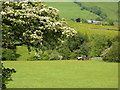
Hawthorn in blossom, and tractor
Farming scene near Kettlehulme.
Image: © Peter Barr
Taken: 31 May 2011
0.14 miles
3
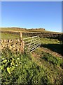
On Taxal Edge
Descending from Windgather Rocks
Image: © Philip Cornwall
Taken: 31 May 2020
0.16 miles
4
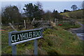
Clayholes Road, above Kettleshulme
Image: © Christopher Hilton
Taken: 1 Jan 2023
0.17 miles
6
Path to Blackhillgate Farm
Either the start or end of Windgather Rocks.
Image: © Brian Frost
Taken: 16 Feb 2018
0.17 miles
7
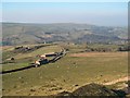
Fivelane-ends
Taken from Windgather Rocks.
Image: © Bill Boaden
Taken: 16 Feb 2008
0.19 miles
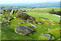
8
Windgather Rocks
Popular with climbers.
Image: © steven ruffles
Taken: 11 Apr 2010
0.19 miles
9

Looking up towards Windgather Rocks from Fivelane-Ends
The house some way up the lane is the former Windgather Cottage Youth Hostel, which opened in 1939 and closed in the mid-1980s. When a hostel, the building had a series of barn-like extensions on the downhill end, which have now been demolished; the range on the right is at least partially a new addition. A photograph of the hostel in the 1970s can be seen at Image The hostel's original purposes will doubtless have included accommodating climbers who had come to scale the gritstone edge of Windgather Rocks.
Image: © Christopher Hilton
Taken: 1 Jan 2023
0.21 miles
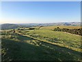
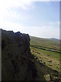
10
Windgather Rocks
Picture taken from track ca 200m NE of Windgather Farm, showing drystone wall field boundary and Wingather Rocks beyond.
Image: © Philip Cornwall
Taken: 31 May 2020
0.22 miles