IMAGES TAKEN NEAR TO
Yeardsley Lane, HIGH PEAK, SK23 7EB
Introduction
This page details the photographs taken nearby to Yeardsley Lane, SK23 7EB by members of the Geograph project.
The Geograph project started in 2005 with the aim of publishing, organising and preserving representative images for every square kilometre of Great Britain, Ireland and the Isle of Man.

There are currently over 7.5m images from over14,400 individuals and you can help contribute to the project by visiting https://www.geograph.org.uk
Image Map
Images are licensed for reuse under creativecommons.org/licenses/by-sa/2.0
Notes
- Clicking on the map will re-center to the selected point.
- The higher the marker number, the further away the image location is from the centre of the postcode.
Image Listing (9 Images Found)
Images are licensed for reuse under creativecommons.org/licenses/by-sa/2.0
Image
Details
Distance
1
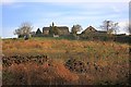
Ringstone
A farmstead standing proud on the hill which has diversified with a caravan and camping site.
Image: © Mick Garratt
Taken: 15 Apr 2010
0.00 miles
2
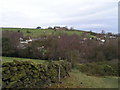
Ringstone Caravan Park
A rather oddly located caravan site around a wooded clough above Bridgemont and Whaley Bridge. Viewpoint is the footpath to Stoneheads, looking north.
Image: © Dave Dunford
Taken: 18 Dec 2005
0.05 miles
3
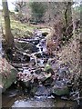
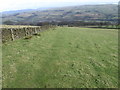
Ringstone Clough
Just below the footpath to Stoneheads
Image: © Dave Dunford
Taken: 18 Dec 2005
0.15 miles
4
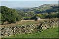
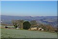
Ruined barn below Ringstone Farm
There are views into the Goyt Valley.
Image: © Bill Boaden
Taken: 13 Oct 2022
0.16 miles
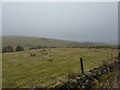
5
A view of Brownough
A former farm south west of Furness Vale
Image: © Neil Theasby
Taken: 8 Dec 2022
0.18 miles
6
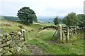
A gate with a view
Looking down to the Goyt Valley at Furness Vale
Image: © Graham Hogg
Taken: 22 Sep 2015
0.20 miles
7
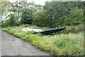
Expecting a high tide?
Two boats beside a moorland track nearly 800' above sea level and some distance from the nearest navigable waterway
Image: © Graham Hogg
Taken: 22 Sep 2015
0.20 miles
9
Ringstone Clough
Hills around Whaley Bridge.
Image: © Peter Barr
Taken: 18 Feb 2011
0.23 miles