IMAGES TAKEN NEAR TO
Stoneheads, HIGH PEAK, SK23 7BB
Introduction
This page details the photographs taken nearby to Stoneheads, SK23 7BB by members of the Geograph project.
The Geograph project started in 2005 with the aim of publishing, organising and preserving representative images for every square kilometre of Great Britain, Ireland and the Isle of Man.

There are currently over 7.5m images from over14,400 individuals and you can help contribute to the project by visiting https://www.geograph.org.uk
Image Map (Loading...)


Getting Data...Please wait
Leaflet Map data © OpenStreetMap
Images are licensed for reuse under creativecommons.org/licenses/by-sa/2.0
Notes
- Clicking on the map will re-center to the selected point.
- The higher the marker number, the further away the image location is from the centre of the postcode.
Image Listing (7 Images Found)
Images are licensed for reuse under creativecommons.org/licenses/by-sa/2.0
Image
Details
Distance
1
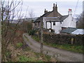
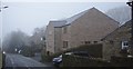
Cottages, Stoneheads
On the bridleway from Stoneheads to Hockerley (two old satellite hamlets of Whaley Bridge, both now surrounded by modern infill housing).
Image: © Dave Dunford
Taken: 18 Dec 2005
0.02 miles
3
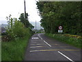
Dropping down into Whaley Bridge
Heading south on Whaley Lane.
Image: © JThomas
Taken: 24 May 2014
0.12 miles
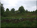
6
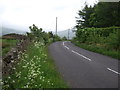
A bend in Whaley Lane
Heading east towards Whaley Bridge.
Image: © JThomas
Taken: 24 May 2014
0.24 miles
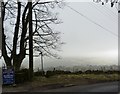
7
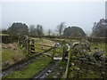
Not much in the way of views today
At about 300 metres, the fog is getting quite thick; it often clears the higher up one goes, but not today; near Stoneheads, west of Whaley.
Image: © Peter Barr
Taken: 18 Feb 2011
0.25 miles