IMAGES TAKEN NEAR TO
Eccles Fold, Whitehough, HIGH PEAK, SK23 6BY
Introduction
This page details the photographs taken nearby to Eccles Fold, Whitehough, SK23 6BY by members of the Geograph project.
The Geograph project started in 2005 with the aim of publishing, organising and preserving representative images for every square kilometre of Great Britain, Ireland and the Isle of Man.

There are currently over 7.5m images from over14,400 individuals and you can help contribute to the project by visiting https://www.geograph.org.uk
Image Map
Images are licensed for reuse under creativecommons.org/licenses/by-sa/2.0
Notes
- Clicking on the map will re-center to the selected point.
- The higher the marker number, the further away the image location is from the centre of the postcode.
Image Listing (21 Images Found)
Images are licensed for reuse under creativecommons.org/licenses/by-sa/2.0
Image
Details
Distance
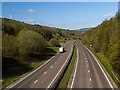
1
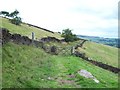
Track to the north of Eccles Pike
Looking towards Buxworth on a good visibility day in mid August.
Image: © Jonathan Clitheroe
Taken: 16 Aug 2009
0.15 miles
2
Eccles Pike from Cote Bank Farm
Looking across the valley to the North side of the pike, from grid ref SK0282
Image: © Liz McCabe
Taken: 18 Jan 2005
0.16 miles
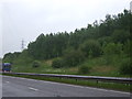
6
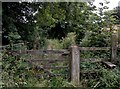
This footpath doesn't look over used!
Hardly surprising as it leads onto a dual carriageway part of the A6, with an equally overgrown path on the other side!
Image: © Chris Morgan
Taken: 10 Sep 2012
0.21 miles
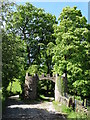
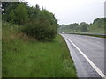
7
A6
A quiet Sunday morning on the A6 near Whitehough.
Image: © Peter McDermott
Taken: 26 Apr 2015
0.22 miles
8
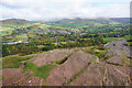
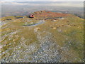
Rocks on the top of Eccles Pike
Looking down towards Chinley with Kinder Scout behind.
Image: © Bill Boaden
Taken: 17 Oct 2015
0.23 miles
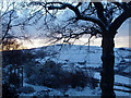
9
Eccles Pike
Easy bag form south for a pleasant hill on a frozen afternoon.
Name: Eccles Pike
Hill number: 5334
Height: 370m / 1214ft
Area: 36: Lancashire, Cheshire & the Southern Pennines
Class: Hu
Grid ref: SK 03530 81226
Summit feature: angled slab 4m E of site of indicator
Drop: 135m
Col: 235m SK053804
Image: © Rude Health
Taken: 26 Nov 2010
0.24 miles
10
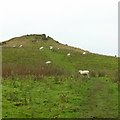
Eccles Pike
The approach from the east. This side of the Pike is open access land.
Image: © Alan Murray-Rust
Taken: 25 Oct 2015
0.24 miles