IMAGES TAKEN NEAR TO
Wicken Lane, HIGH PEAK, SK23 6AN
Introduction
This page details the photographs taken nearby to Wicken Lane, SK23 6AN by members of the Geograph project.
The Geograph project started in 2005 with the aim of publishing, organising and preserving representative images for every square kilometre of Great Britain, Ireland and the Isle of Man.

There are currently over 7.5m images from over14,400 individuals and you can help contribute to the project by visiting https://www.geograph.org.uk
Image Map
Images are licensed for reuse under creativecommons.org/licenses/by-sa/2.0
Notes
- Clicking on the map will re-center to the selected point.
- The higher the marker number, the further away the image location is from the centre of the postcode.
Image Listing (7 Images Found)
Images are licensed for reuse under creativecommons.org/licenses/by-sa/2.0
Image
Details
Distance
2
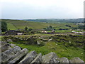
Cattle grazing near Dewsnaps
Hill farmland north of Chinley.
Image: © Peter Barr
Taken: 4 Jul 2011
0.15 miles
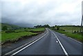
3
The A624 Hayfield Road
Looking in the direction of Hayfield on an overcast Saturday in early June.
Image: © Jonathan Clitheroe
Taken: 2 Jun 2012
0.16 miles
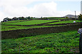
4
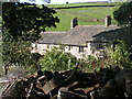
Dewsnaps
Old farmhouse, now offering accommodation. Looking northwest from SK054833, on the footpath leading towards Bennett Barn and Bullhill.
Image: © Dave Dunford
Taken: 24 Sep 2005
0.19 miles
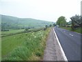
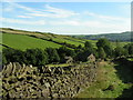
6
Fields above White Knowl Farm
South Head peeps up to the right, a subsidiary peak of Kinder Scout.
Image: © Bill Boaden
Taken: 17 Oct 2015
0.20 miles
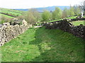
7
Bullhill
Looking SSE from the footpath approx. SK054838.
Image: © Dave Dunford
Taken: 24 Sep 2005
0.24 miles