IMAGES TAKEN NEAR TO
Danesway Cottages, HIGH PEAK, SK23 0TH
Introduction
This page details the photographs taken nearby to Danesway Cottages, SK23 0TH by members of the Geograph project.
The Geograph project started in 2005 with the aim of publishing, organising and preserving representative images for every square kilometre of Great Britain, Ireland and the Isle of Man.

There are currently over 7.5m images from over14,400 individuals and you can help contribute to the project by visiting https://www.geograph.org.uk
Image Map
Images are licensed for reuse under creativecommons.org/licenses/by-sa/2.0
Notes
- Clicking on the map will re-center to the selected point.
- The higher the marker number, the further away the image location is from the centre of the postcode.
Image Listing (212 Images Found)
Images are licensed for reuse under creativecommons.org/licenses/by-sa/2.0
Image
Details
Distance
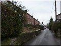
4
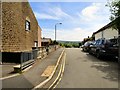
Chapel-en-le-Frith, Hayfield Road
Approaching Chapel-en-le-Frith on Hayfield Road.
Image: © David Dixon
Taken: 4 Oct 2012
0.10 miles
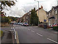
6
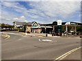
Morrisons, Chapel-en-le-Frith
Off Market Street.
Image: © Gerald England
Taken: 9 Jun 2018
0.11 miles
7
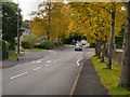
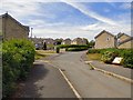
Hayfield Road, Chapel-en-le-Frith
Hayfield Road (A624), leaving Chapel-en-le-Frith.
Image: © David Dixon
Taken: 4 Oct 2012
0.11 miles
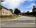
9
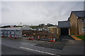
House building on Burrfields Road
Adjacent to the Ferodo factory.
Image: © Peter Barr
Taken: 7 Jan 2015
0.11 miles
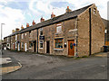
10
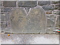
Cut Mark Market Street Chapel-en-le-Frith
Image: © Monica Stagg
Taken: 20 Jul 2015
0.12 miles