IMAGES TAKEN NEAR TO
Thornbrook Road, HIGH PEAK, SK23 0RG
Introduction
This page details the photographs taken nearby to Thornbrook Road, SK23 0RG by members of the Geograph project.
The Geograph project started in 2005 with the aim of publishing, organising and preserving representative images for every square kilometre of Great Britain, Ireland and the Isle of Man.

There are currently over 7.5m images from over14,400 individuals and you can help contribute to the project by visiting https://www.geograph.org.uk
Image Map
Images are licensed for reuse under creativecommons.org/licenses/by-sa/2.0
Notes
- Clicking on the map will re-center to the selected point.
- The higher the marker number, the further away the image location is from the centre of the postcode.
Image Listing (212 Images Found)
Images are licensed for reuse under creativecommons.org/licenses/by-sa/2.0
Image
Details
Distance
1
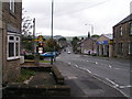
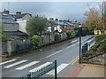
Market Street, Chapel-en-le-Frith
B5470 looking east (viewpoint approx. SK060808) with spire of Methodist Church to right
Image: © Dave Dunford
Taken: 18 Sep 2005
0.03 miles
2
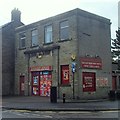
Shop in Chapel-en-le-Frith
Off licence store at the corner of Market Street and Thornbrook Road. The very square cut nature of the building caught my eye.
Image: © Andrew Hill
Taken: 8 Oct 2013
0.04 miles
3

Chapel en le Frith fire station
Chapel en le Frith fire station, Thornbrook Road, Chapel en le Frith, High Peak, Derbyshire
Image: © Kevin Hale
Taken: 29 Jul 2010
0.05 miles
4
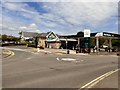
Morrisons, Chapel-en-le-Frith
Off Market Street.
Image: © Gerald England
Taken: 9 Jun 2018
0.06 miles
6
Service road to the supermarket car-park
The road to the supermarket car-park goes behind some of the shops and houses on Market Street.
Image: © Andrew Hill
Taken: 8 Oct 2013
0.06 miles
7
Cut Mark Market Street Chapel-en-le-Frith
Image: © Monica Stagg
Taken: 20 Jul 2015
0.07 miles
8

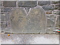
Old Boundary Marker on Marker Street, Chapel en le Frith
Township Boundary Marker set in the parapet of a bridge over Smithy Brook, on the north side of the B5470 Market Street. Chapel-en-le-Frith parish. It is thought to mark the former boundary of Chapel-en-le-Frith and Bowden Edge townships within the parish. See also https://www.geograph.org.uk/photo/4577502.
Milestone Society National ID: DE_CHAP05pb
Image: © D Garside
Taken: 8 Dec 2022
0.07 miles
9
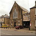
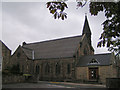
Chapel-en-le-Frith Town Hall
The town hall, on Market Street, was completed in 1851.
http://www.chapel-en-le-frithparishcouncil.gov.uk/halll.htm Some facts about Chapel-en-le-Frith Town Hall.
Image: © David Dixon
Taken: 4 Oct 2012
0.08 miles
10
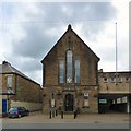
Chapel-en-le-Frith Town Hall
The Town Hall was completed in 1851, at the expense of Dr John Slacke of Bowden Hall and was known as the "New Sessions House" as it provided a new home for the Magistrates' Court, which had met previously in the Royal Oak.
The building also housed the County Court, the Trustee Savings Bank and the High Peak Lodge of the Free Masons, and was used for social functions, dances and theatrical productions.
In 1928 the building was transferred to the Parish Council and in 1934, the ground floor Council Chamber was extended and a permanent stage was installed on the first floor.
During the Second World War, the cellar was used as a base for the St John's Ambulance A.R.P. team.
In 1947, the Chapel-en-le-Frith H.M. Forces Welcome Home Fund came up with a proposal to convert the Town Hall into a War Memorial Hall. Three schemes were put to the public, including a complete re-build in Modernist style. Alterations did not take place until 1970 and these involved the modest addition of a first floor annexe, including an additional function and meeting room.
Current users include Chapel-en-le-Frith Ladies' Choir, Chapel-en-le-Frith Gardening Club, Chapel-en-le-Frith Civic Society, Michael & Jackie's Dancing Class, Judo, Women's Institute, Weight Watchers, and others.
More information could be found on the former Parish Council website: http://web.archive.org/web/20160807182354/http://www.chapel-en-le-frithparishcouncil.gov.uk/halll.htm
Image
Image: © Gerald England
Taken: 16 Sep 2016
0.08 miles