IMAGES TAKEN NEAR TO
The Wash, HIGH PEAK, SK23 0QL
Introduction
This page details the photographs taken nearby to The Wash, SK23 0QL by members of the Geograph project.
The Geograph project started in 2005 with the aim of publishing, organising and preserving representative images for every square kilometre of Great Britain, Ireland and the Isle of Man.

There are currently over 7.5m images from over14,400 individuals and you can help contribute to the project by visiting https://www.geograph.org.uk
Image Map
Images are licensed for reuse under creativecommons.org/licenses/by-sa/2.0
Notes
- Clicking on the map will re-center to the selected point.
- The higher the marker number, the further away the image location is from the centre of the postcode.
Image Listing (8 Images Found)
Images are licensed for reuse under creativecommons.org/licenses/by-sa/2.0
Image
Details
Distance
1
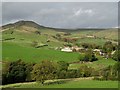
Edge of the Pennines
View northwards from Gorsty Low
Image: © Neil Theasby
Taken: 17 Oct 2013
0.08 miles
2
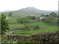
Chinley - Slack House and South Head from Gorsty Low
Image: © Dave Bevis
Taken: 2 Jun 2012
0.08 miles
4
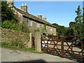
Slack House
18th-century stone farmhouse (typical of many in this area) on quiet lane.
Image: © Dave Dunford
Taken: 24 Sep 2005
0.13 miles
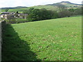
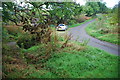
5
Down the lane from Beet Farm
Apart from the farm and an open track to the hills it's a dead end for motor traffic.
Image: © Chris Morgan
Taken: 30 Jun 2014
0.14 miles
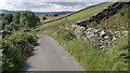
6
New Smithy Ford
This ford is found just below the crossroads at New Smithy.
Image: © John Walton
Taken: 4 Oct 2014
0.17 miles
7
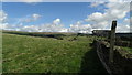
Start of concessionary path up to South Head near New Smithy
Image: © Colin Park
Taken: 23 Sep 2016
0.21 miles
8
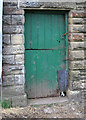
Chinley - door and dog at Hull End
A sheepdog's head can be seen at the bottom right of the stable door.
Image: © Dave Bevis
Taken: 2 Jun 2012
0.21 miles