IMAGES TAKEN NEAR TO
Willow Drive, HIGH PEAK, SK23 0ND
Introduction
This page details the photographs taken nearby to Willow Drive, SK23 0ND by members of the Geograph project.
The Geograph project started in 2005 with the aim of publishing, organising and preserving representative images for every square kilometre of Great Britain, Ireland and the Isle of Man.

There are currently over 7.5m images from over14,400 individuals and you can help contribute to the project by visiting https://www.geograph.org.uk
Image Map
Images are licensed for reuse under creativecommons.org/licenses/by-sa/2.0
Notes
- Clicking on the map will re-center to the selected point.
- The higher the marker number, the further away the image location is from the centre of the postcode.
Image Listing (3 Images Found)
Images are licensed for reuse under creativecommons.org/licenses/by-sa/2.0
Image
Details
Distance
2
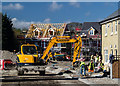
Chapel-en-le-Frith
New housing development at Chapel-en-le-Frith.
Image: © Peter McDermott
Taken: 26 Apr 2015
0.25 miles
3
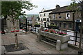
Cattle trough in the market square
Erected to celebrate a jubilee, presumably one of Queen Victoria's who became Queen in 1837.
Image: © Graham Hogg
Taken: 17 Jun 2013
0.25 miles