1
Arch at entrance to War Memorial Park
Image: © Chris Morgan
Taken: 17 Jun 2013
0.05 miles
2
Cattle trough in the market square
Erected to celebrate a jubilee, presumably one of Queen Victoria's who became Queen in 1837.
Image: © Graham Hogg
Taken: 17 Jun 2013
0.10 miles
3
Royal Oak, Chapel-en-le-Frith
The Royal Oak is Grade II listed http://www.britishlistedbuildings.co.uk/en-82028-the-royal-oak-inn-chapel-en-le-frith-derb Before the Town Hall
Image was built in 1851 it was home to the Magistrates' Court.
Image
Image: © Gerald England
Taken: 16 Sep 2016
0.11 miles
4
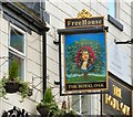
Sign of the Royal Oak
Sign for the Royal Oak
Image
Image: © Gerald England
Taken: 16 Sep 2016
0.11 miles
5
B5470 Market Street, Chapel-en-le-Frith
Image: © Peter Turner
Taken: 10 Mar 2012
0.11 miles
6
Vecchia Italia
Italian restaurant in Market Street, the B5470, in Chapel-en-le-Frith. Visible higher up the street is the Royal Oak.
Image: © Gerald England
Taken: 16 Sep 2016
0.11 miles
7
Hearse House, Chapel-en-le-Frith
The Hearse House, 42 Market Street, Chapel-en-le-Frith was an undertaker's cartshed. Erected in 1818, the building is now used as an Information Centre, and is a Grade II listed structure.
Image: © Alan Fleming
Taken: 2 May 2005
0.11 miles
8
Cut Mark High Street Chapel-en-le-Frith
Image: © Monica Stagg
Taken: 20 Jul 2015
0.11 miles
9
Chapel-en-le-Frith Market Cross
The cobbled market place is raised above the High Street. This cross carries a faint date which may read 1636, but the cross itself is believed to be considerably older*.
*Neville T Sharpe, Crosses of the Peak District (Landmark Collectors Library, 2002)
Image: © David Dixon
Taken: 4 Oct 2012
0.11 miles
10
Chapel-en-le-Frith War Memorial
The war memorial in Chapel-en-le-Frith Market Place.
The inscription on the dome reads:
Erected 1919 to record the honoured names of the men from the Parish of Chapel-en-le-Frith who served in the Great War.
and on the face:
THIS MEMORIAL
ERECTED BY PUBLIC SUBSCRIPTION
WAS DEDICATED BY BRIGADIER GENERAL
GODFREY D. GOODMAN. C.M.G., D.S.O., V.D.
WHO COMMANDED THE 6TH BATTALION
SHERWOOD FORESTERS AND 52nd AND 21st
INFANTRY BRIGADES.
5th JULY 1919.
for a list of names, see http://www.chapel-en-le-frithparishcouncil.gov.uk/warmemorial.htm
The memorial is a Grade II listed structure (http://www.britishlistedbuildings.co.uk/en-82023-war-memorial-chapel-en-le-frith-derbyshir British Listed Buildings)
Image: © David Dixon
Taken: 4 Oct 2012
0.12 miles


