IMAGES TAKEN NEAR TO
Laneside Road, HIGH PEAK, SK22 4LU
Introduction
This page details the photographs taken nearby to Laneside Road, SK22 4LU by members of the Geograph project.
The Geograph project started in 2005 with the aim of publishing, organising and preserving representative images for every square kilometre of Great Britain, Ireland and the Isle of Man.

There are currently over 7.5m images from over14,400 individuals and you can help contribute to the project by visiting https://www.geograph.org.uk
Image Map
Images are licensed for reuse under creativecommons.org/licenses/by-sa/2.0
Notes
- Clicking on the map will re-center to the selected point.
- The higher the marker number, the further away the image location is from the centre of the postcode.
Image Listing (6 Images Found)
Images are licensed for reuse under creativecommons.org/licenses/by-sa/2.0
Image
Details
Distance
1
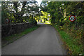
Laneside Road
Entering Low Leighton which runs into New Mills.
Image: © Bill Boaden
Taken: 13 Oct 2022
0.11 miles
2

Field in the Sett valley
The bottom end of the valley near New Mills.
Image: © Bill Boaden
Taken: 13 Oct 2022
0.21 miles
3
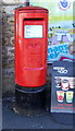
Elizabeth II postbox on Low Leighton Road
Postbox No. SK22 56.
See Image] for context.
Image: © JThomas
Taken: 30 Jun 2018
0.23 miles
4
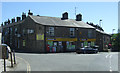
Convenience store on Low Leighton Road
Showing position of Postbox No. SK22 56.
See Image] for postbox.
Image: © JThomas
Taken: 30 Jun 2018
0.23 miles
5

New Mills fire station
New Mills fire station, Low Leighton Road, New Mills, High Peak, Derbyshire
Image: © Kevin Hale
Taken: 29 Jul 2010
0.24 miles
6
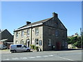
The Hare & Hounds, New Mills
On Low Leighton Road.
Image: © JThomas
Taken: 30 Jun 2018
0.25 miles