IMAGES TAKEN NEAR TO
Lantern View, HIGH PEAK, SK22 3EE
Introduction
This page details the photographs taken nearby to Lantern View, SK22 3EE by members of the Geograph project.
The Geograph project started in 2005 with the aim of publishing, organising and preserving representative images for every square kilometre of Great Britain, Ireland and the Isle of Man.

There are currently over 7.5m images from over14,400 individuals and you can help contribute to the project by visiting https://www.geograph.org.uk
Image Map
Images are licensed for reuse under creativecommons.org/licenses/by-sa/2.0
Notes
- Clicking on the map will re-center to the selected point.
- The higher the marker number, the further away the image location is from the centre of the postcode.
Image Listing (21 Images Found)
Images are licensed for reuse under creativecommons.org/licenses/by-sa/2.0
Image
Details
Distance
1
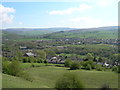
View to Kinder
Looking N/E over New Mills, up the Sett Valley towards Birch Vale, Hayfield and Kinder Scout.
Image: © John Topping
Taken: 5 May 2006
0.10 miles
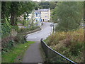
2
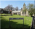
St James's Square in New Mills
St James's Church to the right is now a community arts centre.
Image: © Neil Theasby
Taken: 23 Apr 2015
0.16 miles
3
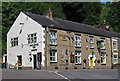
New Mills - Pineapple Inn
On Dye House Road. For an alternative view, please see Image
Image: © Dave Bevis
Taken: 26 Jul 2013
0.19 miles
4
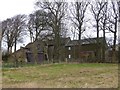
Eaves Knoll Farmhouse
Grade II listed farmhouse on the outskirts of New Mills https://historicengland.org.uk/listing/the-list/list-entry/1039939.
Image: © Dave Dunford
Taken: 1 Jan 2015
0.19 miles
6
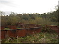
Filter Beds
Site of the old Sewage Treatment Works.
Image: © Darren Haddock
Taken: 10 Nov 2006
0.20 miles
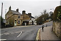
7
Pineapple Inn on Dye House Lane, New Mills
Image: © Peter Barr
Taken: 28 Mar 2011
0.21 miles
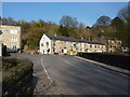
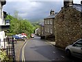
8
Bottom of Dye House Lane
Road Junction with Hyde Bank, Dye House Lane and High Street. The building in front used to be Ron's corner shop and was a favourite with the kids. For the adults there is the Pineapple Pub on the right.
Image: © Darren Haddock
Taken: 10 Nov 2006
0.21 miles
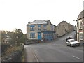
10
Pub on the crossroads: The White Hart in New Mills
Almost all the pubs are Robinson's ones in this area. This is at the southern end of Mellor Road.
Image: © Bill Boaden
Taken: 5 Mar 2011
0.21 miles