IMAGES TAKEN NEAR TO
Aspenshaw Road, HIGH PEAK, SK22 1AT
Introduction
This page details the photographs taken nearby to Aspenshaw Road, SK22 1AT by members of the Geograph project.
The Geograph project started in 2005 with the aim of publishing, organising and preserving representative images for every square kilometre of Great Britain, Ireland and the Isle of Man.

There are currently over 7.5m images from over14,400 individuals and you can help contribute to the project by visiting https://www.geograph.org.uk
Image Map
Images are licensed for reuse under creativecommons.org/licenses/by-sa/2.0
Notes
- Clicking on the map will re-center to the selected point.
- The higher the marker number, the further away the image location is from the centre of the postcode.
Image Listing (23 Images Found)
Images are licensed for reuse under creativecommons.org/licenses/by-sa/2.0
Image
Details
Distance
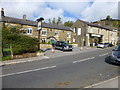
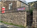
1
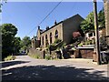
Aspenshaw Road junction with Sitch Lane
The Old School House is on the right
Image: © Eirian Evans
Taken: 14 Jun 2023
0.01 miles
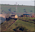
5
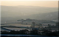
Highwalls Farm
Highwalls farm occupies a prominent position on a spur of land overlooking New Mills and the hills around Lyme Park.
Image: © John Hargreaves
Taken: 6 Jan 2009
0.07 miles
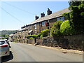
6
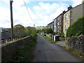
Terraced housing in Stitch Lane, Thornsett
Image: © Raymond Knapman
Taken: 10 Oct 2014
0.09 miles
7
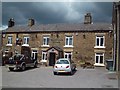
Printers Arms in Thornsett
A Free House situated just outside New Mills.
Image: © Jonathan Clitheroe
Taken: 23 Jul 2011
0.10 miles
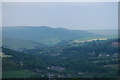
9
Thornsett Primary School
This school, rising steeply above Thornsett Brows, has wonderful views over the Derbyshire countryside.
Image: © Roger May
Taken: 20 Aug 2005
0.11 miles
10
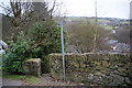
Footpath in Thornsett
Thornsett Industrial Estate can be seen at the bottom of the valley.
Image: © Bill Boaden
Taken: 5 Mar 2011
0.15 miles