IMAGES TAKEN NEAR TO
Sycamore Road, HIGH PEAK, SK22 1AG
Introduction
This page details the photographs taken nearby to Sycamore Road, SK22 1AG by members of the Geograph project.
The Geograph project started in 2005 with the aim of publishing, organising and preserving representative images for every square kilometre of Great Britain, Ireland and the Isle of Man.

There are currently over 7.5m images from over14,400 individuals and you can help contribute to the project by visiting https://www.geograph.org.uk
Image Map
Images are licensed for reuse under creativecommons.org/licenses/by-sa/2.0
Notes
- Clicking on the map will re-center to the selected point.
- The higher the marker number, the further away the image location is from the centre of the postcode.
Image Listing (25 Images Found)
Images are licensed for reuse under creativecommons.org/licenses/by-sa/2.0
Image
Details
Distance
1
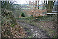
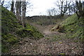
Footpath in Thornsett
Thornsett Industrial Estate can be seen at the bottom of the valley.
Image: © Bill Boaden
Taken: 5 Mar 2011
0.05 miles
2
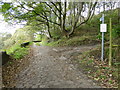
Signage at Stitch Lane,Thornsett
The public footpath sign shows the way down to the Sett Valley Trail
Image: © Raymond Knapman
Taken: 10 Oct 2014
0.06 miles
5
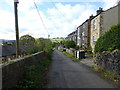
Terraced housing in Stitch Lane, Thornsett
Image: © Raymond Knapman
Taken: 10 Oct 2014
0.10 miles
7
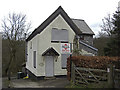
Wildes Crossing Cottage
Now up for sale and looking rather forlorn. To see how it looked a few months ago click http://www.geograph.org.uk/photo/1066150
Image: © michael ely
Taken: 22 Feb 2009
0.13 miles
8
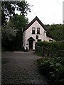
Wildes Crossing, Sett Valley Trail
The branch line to Hayfield closed in 1970 and is now maintained as a cycling and horse-riding route, the Sett Valley Trail (seen here passing through the gate in front of the house). Two of the former level crossing houses along the line survive, including this one at Wildes Crossing down a cobbled lane (see foreground) between Birch Vale and Thornsett. Viewpoint approx. SK014867, looking north.
Image: © Dave Dunford
Taken: 9 Sep 2005
0.13 miles
10
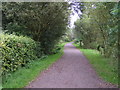
Sett Valley Trail
Looking east along the Sett Valley Trail from Wilkes' Crossing. The Sett Valley Trail is a 2.5-mile recreational route from Hayfield to New Mills following the trackbed of the former LNER branch line to Hayfield along the valley of the River Sett.
Image: © Dave Dunford
Taken: 9 Sep 2005
0.13 miles