IMAGES TAKEN NEAR TO
Taddington, BUXTON, SK17 9UJ
Introduction
This page details the photographs taken nearby to SK17 9UJ by members of the Geograph project.
The Geograph project started in 2005 with the aim of publishing, organising and preserving representative images for every square kilometre of Great Britain, Ireland and the Isle of Man.

There are currently over 7.5m images from over14,400 individuals and you can help contribute to the project by visiting https://www.geograph.org.uk
Image Map
Images are licensed for reuse under creativecommons.org/licenses/by-sa/2.0
Notes
- Clicking on the map will re-center to the selected point.
- The higher the marker number, the further away the image location is from the centre of the postcode.
Image Listing (15 Images Found)
Images are licensed for reuse under creativecommons.org/licenses/by-sa/2.0
Image
Details
Distance
1
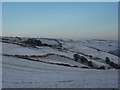
Deep Dale Lodge
Red roof and red car, and sheep in snow covered fields. White Peak, Derbyshire, in winter.
Image: © Peter Barr
Taken: 20 Dec 2010
0.06 miles
2
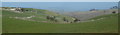
View to Deep Dale
Open view to the valley from the track south of Over Wheal. Deep Dale Lodge can be seen to the left.
Image: © Andrew Hill
Taken: 13 Mar 2012
0.16 miles
3
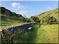
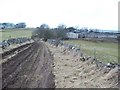
Footpath running alongside wall in Deep Dale
Image: © Philip Cornwall
Taken: 30 Jun 2021
0.18 miles
4
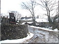
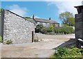
Over Wheal Farm in winter; near Taddington
Image: © Peter Barr
Taken: 11 Feb 2009
0.18 miles
5
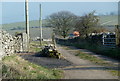
Farm track to Deep Dale Lodge
View from the track and lane junction near Over Wheal.
Image: © Andrew Hill
Taken: 13 Mar 2012
0.19 miles
6

Deep Dale from above
Looking down along the valley from the footpath near Over Wheel.
Image: © Andrew Hill
Taken: 13 Mar 2012
0.19 miles
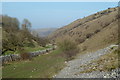
7
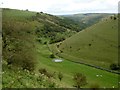
Deep Dale
From a footpath at the south end of the dale.
Image: © Graham Hogg
Taken: 17 Sep 2012
0.20 miles
8
Muddy Track leading to Over Wheal Farm
This picture was taken on a dry but partly overcast Saturday in early March. Thanks to Andy Whitehouse for his assistance and anecdotes.
Image: © Jonathan Clitheroe
Taken: 6 Mar 2010
0.20 miles
10
Limestone valley, Deep Dale
Looking north down the valley, with exposed limestone scree in the foreground.
Image: © Andrew Hill
Taken: 13 Mar 2012
0.21 miles