IMAGES TAKEN NEAR TO
Main Street, BUXTON, SK17 9TX
Introduction
This page details the photographs taken nearby to Main Street, SK17 9TX by members of the Geograph project.
The Geograph project started in 2005 with the aim of publishing, organising and preserving representative images for every square kilometre of Great Britain, Ireland and the Isle of Man.

There are currently over 7.5m images from over14,400 individuals and you can help contribute to the project by visiting https://www.geograph.org.uk
Image Map
Images are licensed for reuse under creativecommons.org/licenses/by-sa/2.0
Notes
- Clicking on the map will re-center to the selected point.
- The higher the marker number, the further away the image location is from the centre of the postcode.
Image Listing (110 Images Found)
Images are licensed for reuse under creativecommons.org/licenses/by-sa/2.0
Image
Details
Distance
1
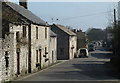
Main Road, Taddington
Looking east from close to the entrance to the churchyard.
Image: © Andrew Hill
Taken: 13 Mar 2012
0.01 miles
2
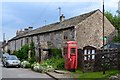
Terrace of cottages in Taddington
With "communications" aids - red phone box, post box and parish noticeboard.
Image: © Neil Theasby
Taken: 20 Jun 2012
0.01 miles


6
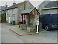
Bus stop and milepost
At the up to Buxton stop is this attractive restored milepost
Image: © John Poyser
Taken: 4 May 2007
0.03 miles
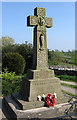
7

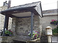
Lychgate to Taddington Church
Lychgate to Taddington Church with the war memorial on the right.
Image: © Philip Halling
Taken: 18 May 2022
0.03 miles
10

Graveyard at St Michael & All Angels, Taddington
Image: © Ian S
Taken: 30 Jan 2015
0.04 miles