IMAGES TAKEN NEAR TO
Flagg, BUXTON, SK17 9RA
Introduction
This page details the photographs taken nearby to SK17 9RA by members of the Geograph project.
The Geograph project started in 2005 with the aim of publishing, organising and preserving representative images for every square kilometre of Great Britain, Ireland and the Isle of Man.

There are currently over 7.5m images from over14,400 individuals and you can help contribute to the project by visiting https://www.geograph.org.uk
Image Map
Images are licensed for reuse under creativecommons.org/licenses/by-sa/2.0
Notes
- Clicking on the map will re-center to the selected point.
- The higher the marker number, the further away the image location is from the centre of the postcode.
Image Listing (3 Images Found)
Images are licensed for reuse under creativecommons.org/licenses/by-sa/2.0
Image
Details
Distance
1
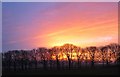
Avenue of trees against autumn sunset, Bosley Fields Farm
Image: © Ron Perry
Taken: Unknown
0.12 miles
2
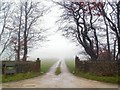
Moor Grange
I hope you'll take it as read, that Moor Grange stands at the head of this drive leading off Moor Lane near Taddington. The name of the grange is etched into the stone gateposts.
Image: © Roger May
Taken: 10 Dec 2005
0.17 miles
3
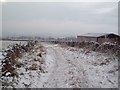
Whitefield Lane
A solitary barn sits alongside a frozen farm track on a sub-zero degree day in mid December.
Image: © Jonathan Clitheroe
Taken: 18 Dec 2010
0.22 miles