IMAGES TAKEN NEAR TO
Flagg, BUXTON, SK17 9QW
Introduction
This page details the photographs taken nearby to SK17 9QW by members of the Geograph project.
The Geograph project started in 2005 with the aim of publishing, organising and preserving representative images for every square kilometre of Great Britain, Ireland and the Isle of Man.

There are currently over 7.5m images from over14,400 individuals and you can help contribute to the project by visiting https://www.geograph.org.uk
Image Map
Images are licensed for reuse under creativecommons.org/licenses/by-sa/2.0
Notes
- Clicking on the map will re-center to the selected point.
- The higher the marker number, the further away the image location is from the centre of the postcode.
Image Listing (5 Images Found)
Images are licensed for reuse under creativecommons.org/licenses/by-sa/2.0
Image
Details
Distance
2
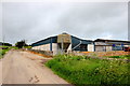
Barns on Stonebench Lane
These barns belong to Moor Farm which as well as being a working farm is a B&B establishment.
Image: © Nigel Mykura
Taken: 10 Jun 2017
0.16 miles
4

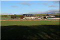
Crossroads north of Flagg Moor Farm
Stonebench Lane (left), Moor Lane (right), and Pasture Lane (ahead).
Image: © Tim Heaton
Taken: 4 Nov 2021
0.17 miles
