IMAGES TAKEN NEAR TO
Flagg, BUXTON, SK17 9QE
Introduction
This page details the photographs taken nearby to SK17 9QE by members of the Geograph project.
The Geograph project started in 2005 with the aim of publishing, organising and preserving representative images for every square kilometre of Great Britain, Ireland and the Isle of Man.

There are currently over 7.5m images from over14,400 individuals and you can help contribute to the project by visiting https://www.geograph.org.uk
Image Map
Images are licensed for reuse under creativecommons.org/licenses/by-sa/2.0
Notes
- Clicking on the map will re-center to the selected point.
- The higher the marker number, the further away the image location is from the centre of the postcode.
Image Listing (15 Images Found)
Images are licensed for reuse under creativecommons.org/licenses/by-sa/2.0
Image
Details
Distance
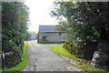
1
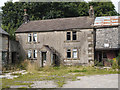
Great Low Farm, Nr Buxton, Derbyshire
Derelict farmhouse near Buxton in Derbyshire. At the time of submission, the property was for sale with offers in excess of £450,000 invited.
Image: © Martin Froggatt
Taken: 4 Aug 2019
0.01 miles
2
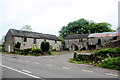
Greatlow Farm
These buildings appear to be in very poor condition, verging on dereliction. This may have something to with the fact that in August 2016 the farmer, Anthony Melland and his mother were banned for life from keeping horses. Several horses were found at this farm in February 2016 in appalling conditions. Three dogs were also found in dreadful conditions http://www.derbytelegraph.co.uk/derbyshire-farmer-and-his-mother-banned-for-life-from-keeping-horses/story-29618499-detail/story.html
The farm also played a significant part in a murder case in 2005, when the murderer stopped here with a dead body in an oil drum and had sex with a young woman living here. http://www.derbyshiretimes.co.uk/news/callous-killer-gets-life-1-462127
See also Image
Image: © Nigel Mykura
Taken: 10 Jun 2017
0.02 miles
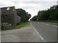
3
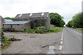
Greatlow Farm Buildings
This is the A515 at Greatlow Farm. There is a caravan site at the side of the farm and there is a very old sign on the farmhouse facing this building which says :-
Sycamores Caravan Site
The view in the opposite ditrection along the A515 can be seen in Image
Image: © Nigel Mykura
Taken: 10 Jun 2017
0.02 miles
4
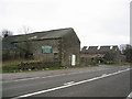
Greatlow Farm
These semi-derelict barns form a buffer between the main farm buildings and the busy A515 from Buxton to Ashbourne.
Image: © Roger Temple
Taken: 13 Jan 2007
0.03 miles
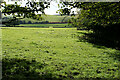
5
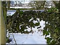
Step stile by Dowlow Farm
This step stile takes a public footpath across the wall. The footpath is difficult to follow, as it is not signposted, is overgrown in places and is blocked by a barbed-wire fence nearby.
Image: © Ian Calderwood
Taken: 14 Jan 2017
0.04 miles
6
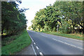
The A515 at Greatlow
The A515 has some great views from its elevated route, but not in this short stretch which is bounded by trees.
Image: © Bill Boaden
Taken: 6 Oct 2021
0.06 miles
7
Dowlow Farm
As seen from the A515. Most of the farm is screened from the road by trees.
Image: © Bill Boaden
Taken: 6 Oct 2021
0.11 miles
9
A515 south east passing Greatlow Farm
Image: © Peter Robinson
Taken: 24 Aug 2011
0.14 miles
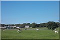
10
Field by Dowlow Farm
The fields extend to Dowlow Quarry land where a line of railway trucks can be seen.
Image: © Bill Boaden
Taken: 6 Oct 2021
0.15 miles