IMAGES TAKEN NEAR TO
Wingfield Crescent, SK17 9GY
Introduction
This page details the photographs taken nearby to Wingfield Crescent, SK17 9GY by members of the Geograph project.
The Geograph project started in 2005 with the aim of publishing, organising and preserving representative images for every square kilometre of Great Britain, Ireland and the Isle of Man.

There are currently over 7.5m images from over14,400 individuals and you can help contribute to the project by visiting https://www.geograph.org.uk
Image Map
Images are licensed for reuse under creativecommons.org/licenses/by-sa/2.0
Notes
- Clicking on the map will re-center to the selected point.
- The higher the marker number, the further away the image location is from the centre of the postcode.
Image Listing (19 Images Found)
Images are licensed for reuse under creativecommons.org/licenses/by-sa/2.0
Image
Details
Distance
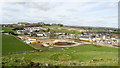
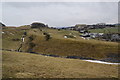
2
Harpur Hill houses
On the south east of Buxton, taken from the former quarry railway.
Image: © Peter Barr
Taken: 8 Apr 2013
0.08 miles
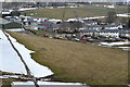
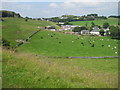
3

Two calves racing each other
Just west of Hillhead Lane near Harpur Hill
Image: © Neil Theasby
Taken: 11 Jun 2018
0.09 miles
4

Disused railway line for the quarries at Harpur Hill
This served the former quarries at Harpur Hill & Hillhead, taking stone onto the main network via Buxton or down towards Matlock.
Image: © Richard Law
Taken: 18 May 2010
0.10 miles
5
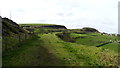
Dismantled railway now walkway below Hillhead Quarry
Image: © Colin Park
Taken: 16 Mar 2020
0.11 miles
9
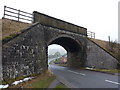
Railway bridge at Harpur Hill
Carrying the spur line from Hind Low quarries
Image: © Peter Barr
Taken: 21 Jan 2010
0.13 miles
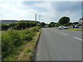
10
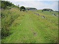
Footpath towards Harpur Hill near Hillhead Quarry
Image: © Chris Wimbush
Taken: 28 Jul 2011
0.14 miles