IMAGES TAKEN NEAR TO
Ashover Close, BUXTON, SK17 9GG
Introduction
This page details the photographs taken nearby to Ashover Close, SK17 9GG by members of the Geograph project.
The Geograph project started in 2005 with the aim of publishing, organising and preserving representative images for every square kilometre of Great Britain, Ireland and the Isle of Man.

There are currently over 7.5m images from over14,400 individuals and you can help contribute to the project by visiting https://www.geograph.org.uk
Image Map
Images are licensed for reuse under creativecommons.org/licenses/by-sa/2.0
Notes
- Clicking on the map will re-center to the selected point.
- The higher the marker number, the further away the image location is from the centre of the postcode.
Image Listing (11 Images Found)
Images are licensed for reuse under creativecommons.org/licenses/by-sa/2.0
Image
Details
Distance
1
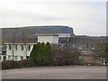
Harpur Hill College
View west from the rear car park at Harpur Hill College, looking over the roof of the main block to the escarpment on the opposite side of the main road, which separates the old quarries from the village.
Image: © Roger May
Taken: 9 Dec 2005
0.13 miles
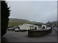
3
Harpur Hill, Buxton
On the outskirts of Buxton, in quarrying country.
Image: © Peter Barr
Taken: 10 Apr 2010
0.14 miles
4
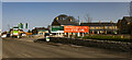
College Hill Park
New housing development in Buxton.
Image: © Peter McDermott
Taken: 30 Mar 2021
0.16 miles
5
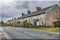
52 - 62 Burlow Road
19th Century quarry workers' cottages on Burlow Road marked on older maps as Burlow Cottages, first recorded in the 1881 census.
Image: © Ian Capper
Taken: 12 Mar 2024
0.17 miles
6
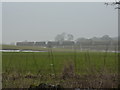
Freight train in the mist
Wagons from Hind Low limestone quarries; a few less lorries on the roads !
Image: © Peter Barr
Taken: 21 Jan 2010
0.19 miles
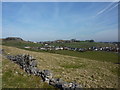
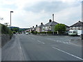
7
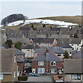
Harpur Hill with snow and semis
Houses on the south side of Buxton, in early April.
Image: © Peter Barr
Taken: 8 Apr 2013
0.20 miles
8
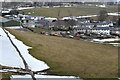
Harpur Hill houses
On the south east of Buxton, taken from the former quarry railway.
Image: © Peter Barr
Taken: 8 Apr 2013
0.22 miles
9
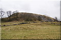
Spoil heap above Harpur Hill
A relic of former quarrying.
Image: © Bill Boaden
Taken: 22 Feb 2013
0.23 miles
10
Burlow Road in Harpur Hill
Housing estates on the south side of Buxton.
Image: © Richard Law
Taken: 6 Jul 2018
0.23 miles